You are here: Home > Network List > O2 - Oklahoma Consolidated Temporary Seismic Networks Stations List
> Station SC20 Lookeba, Oklahoma, USA > Earthquake Result Viewer
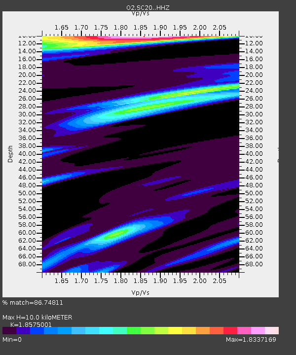
SC20 Lookeba, Oklahoma, USA - Earthquake Result Viewer
| Earthquake location: |
North Atlantic Ocean |
| Earthquake latitude/longitude: |
20.0/-61.1 |
| Earthquake time(UTC): |
2023/07/10 (191) 20:28:25 GMT |
| Earthquake Depth: |
10 km |
| Earthquake Magnitude: |
6.6 mww |
| Earthquake Catalog/Contributor: |
NEIC PDE/us |
|
| Network: |
O2 Oklahoma Consolidated Temporary Seismic Networks |
| Station: |
SC20 Lookeba, Oklahoma, USA |
| Lat/Lon: |
35.40 N/98.44 W |
| Elevation: |
490 m |
|
| Distance: |
36.2 deg |
| Az: |
302.956 deg |
| Baz: |
105.026 deg |
| Ray Param: |
0.07683873 |
| Estimated Moho Depth: |
10.0 km |
| Estimated Crust Vp/Vs: |
1.86 |
| Assumed Crust Vp: |
6.315 km/s |
| Estimated Crust Vs: |
3.4 km/s |
| Estimated Crust Poisson's Ratio: |
0.30 |
|
| Radial Match: |
86.74811 % |
| Radial Bump: |
334 |
| Transverse Match: |
65.49377 % |
| Transverse Bump: |
400 |
| SOD ConfigId: |
30536071 |
| Insert Time: |
2023-07-24 21:09:11.085 +0000 |
| GWidth: |
2.5 |
| Max Bumps: |
400 |
| Tol: |
0.001 |
|

Signal To Noise
| Channel | StoN | STA | LTA |
| O2:SC20: :HHZ:20230710T20:34:57.739992Z | 15.71787 | 1.9958725E-6 | 1.269811E-7 |
| O2:SC20: :HHN:20230710T20:34:57.739992Z | 1.5143856 | 2.0319875E-7 | 1.3417902E-7 |
| O2:SC20: :HHE:20230710T20:34:57.739992Z | 3.6146505 | 5.4285334E-7 | 1.5018142E-7 |
| Arrivals |
| Ps | 1.5 SECOND |
| PpPs | 4.2 SECOND |
| PsPs/PpSs | 5.7 SECOND |


