You are here: Home > Network List > PQ - Public Safety Geoscience Program Canadian Research Network (PSGP) Stations List
> Station TUKN Tuktoyaktuk, NWT, Canada > Earthquake Result Viewer
TUKN Tuktoyaktuk, NWT, Canada - Earthquake Result Viewer
| Earthquake location: |
North Atlantic Ocean |
| Earthquake latitude/longitude: |
20.0/-61.1 |
| Earthquake time(UTC): |
2023/07/10 (191) 20:28:25 GMT |
| Earthquake Depth: |
10 km |
| Earthquake Magnitude: |
6.6 mww |
| Earthquake Catalog/Contributor: |
NEIC PDE/us |
|
| Network: |
PQ Public Safety Geoscience Program Canadian Research Network (PSGP) |
| Station: |
TUKN Tuktoyaktuk, NWT, Canada |
| Lat/Lon: |
69.44 N/132.99 W |
| Elevation: |
2.0 m |
|
| Distance: |
65.1 deg |
| Az: |
338.264 deg |
| Baz: |
99.719 deg |
| Ray Param: |
0.058521777 |
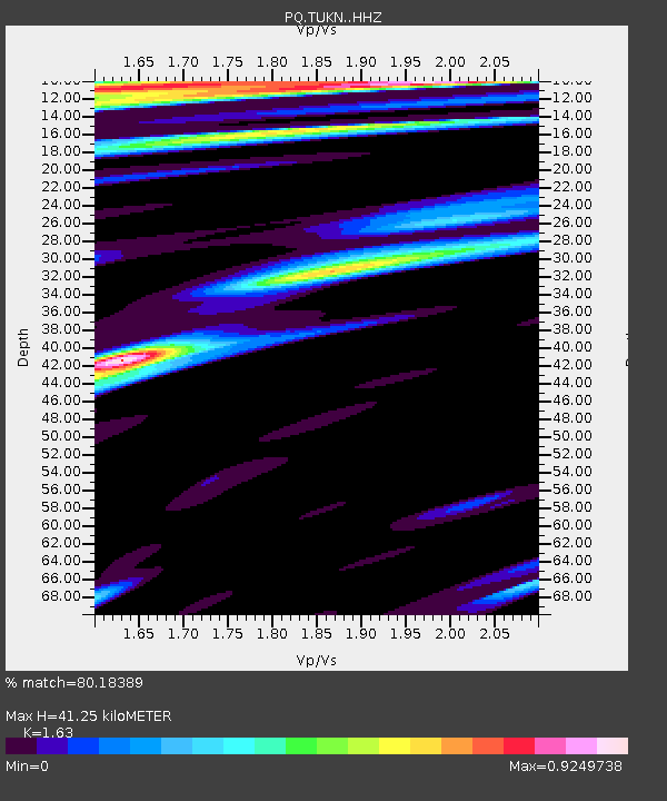
| Estimated Moho Depth: |
41.25 km |
| Estimated Crust Vp/Vs: |
1.63 |
| Assumed Crust Vp: |
6.171 km/s |
| Estimated Crust Vs: |
3.786 km/s |
| Estimated Crust Poisson's Ratio: |
0.20 |
|
| Radial Match: |
80.18389 % |
| Radial Bump: |
400 |
| Transverse Match: |
79.59511 % |
| Transverse Bump: |
400 |
| SOD ConfigId: |
30536071 |
| Insert Time: |
2023-07-24 21:11:59.905 +0000 |
| GWidth: |
2.5 |
| Max Bumps: |
400 |
| Tol: |
0.001 |
|

Signal To Noise
| Channel | StoN | STA | LTA |
| PQ:TUKN: :HHZ:20230710T20:38:35.089998Z | 4.6537423 | 1.1870377E-6 | 2.5507165E-7 |
| PQ:TUKN: :HHN:20230710T20:38:35.089998Z | 0.8866115 | 1.5562688E-7 | 1.7552995E-7 |
| PQ:TUKN: :HHE:20230710T20:38:35.089998Z | 1.4434919 | 4.2697778E-7 | 2.9579508E-7 |
| Arrivals |
| Ps | 4.4 SECOND |
| PpPs | 17 SECOND |
| PsPs/PpSs | 21 SECOND |


