You are here: Home > Network List > PQ - Public Safety Geoscience Program Canadian Research Network (PSGP) Stations List
> Station TSIIG Tsiigehtchic, Northwest Territory > Earthquake Result Viewer
TSIIG Tsiigehtchic, Northwest Territory - Earthquake Result Viewer
| Earthquake location: |
North Atlantic Ocean |
| Earthquake latitude/longitude: |
20.0/-61.1 |
| Earthquake time(UTC): |
2023/07/10 (191) 20:28:25 GMT |
| Earthquake Depth: |
10 km |
| Earthquake Magnitude: |
6.6 mww |
| Earthquake Catalog/Contributor: |
NEIC PDE/us |
|
| Network: |
PQ Public Safety Geoscience Program Canadian Research Network (PSGP) |
| Station: |
TSIIG Tsiigehtchic, Northwest Territory |
| Lat/Lon: |
67.44 N/133.74 W |
| Elevation: |
56 m |
|
| Distance: |
65.0 deg |
| Az: |
336.03 deg |
| Baz: |
98.082 deg |
| Ray Param: |
0.058546416 |
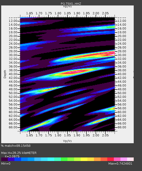
| Estimated Moho Depth: |
29.25 km |
| Estimated Crust Vp/Vs: |
2.10 |
| Assumed Crust Vp: |
6.171 km/s |
| Estimated Crust Vs: |
2.942 km/s |
| Estimated Crust Poisson's Ratio: |
0.35 |
|
| Radial Match: |
89.15458 % |
| Radial Bump: |
400 |
| Transverse Match: |
73.265686 % |
| Transverse Bump: |
400 |
| SOD ConfigId: |
30536071 |
| Insert Time: |
2023-07-24 21:12:02.655 +0000 |
| GWidth: |
2.5 |
| Max Bumps: |
400 |
| Tol: |
0.001 |
|

Signal To Noise
| Channel | StoN | STA | LTA |
| PQ:TSIIG: :HHZ:20230710T20:38:34.850008Z | 7.3016815 | 7.489967E-7 | 1.0257866E-7 |
| PQ:TSIIG: :HHN:20230710T20:38:34.850008Z | 1.7131053 | 1.12357284E-7 | 6.558691E-8 |
| PQ:TSIIG: :HHE:20230710T20:38:34.850008Z | 3.685114 | 3.5102462E-7 | 9.5254755E-8 |
| Arrivals |
| Ps | 5.4 SECOND |
| PpPs | 14 SECOND |
| PsPs/PpSs | 20 SECOND |


