You are here: Home > Network List > IU - Global Seismograph Network (GSN - IRIS/USGS) Stations List
> Station GNI Garni, Armenia > Earthquake Result Viewer
GNI Garni, Armenia - Earthquake Result Viewer
| Earthquake location: |
Andaman Islands, India Region |
| Earthquake latitude/longitude: |
11.1/93.5 |
| Earthquake time(UTC): |
2010/05/31 (151) 19:51:45 GMT |
| Earthquake Depth: |
112 km |
| Earthquake Magnitude: |
6.1 MB, 6.5 MW, 6.4 MW |
| Earthquake Catalog/Contributor: |
WHDF/NEIC |
|
| Network: |
IU Global Seismograph Network (GSN - IRIS/USGS) |
| Station: |
GNI Garni, Armenia |
| Lat/Lon: |
40.15 N/44.74 E |
| Elevation: |
1609 m |
|
| Distance: |
51.7 deg |
| Az: |
312.791 deg |
| Baz: |
110.016 deg |
| Ray Param: |
0.06685701 |
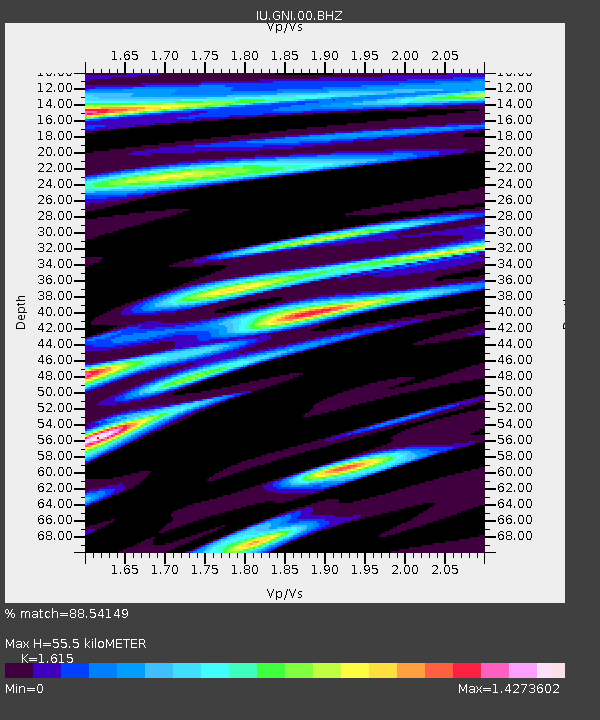
| Estimated Moho Depth: |
55.5 km |
| Estimated Crust Vp/Vs: |
1.62 |
| Assumed Crust Vp: |
6.291 km/s |
| Estimated Crust Vs: |
3.895 km/s |
| Estimated Crust Poisson's Ratio: |
0.19 |
|
| Radial Match: |
88.54149 % |
| Radial Bump: |
400 |
| Transverse Match: |
90.80646 % |
| Transverse Bump: |
400 |
| SOD ConfigId: |
317696 |
| Insert Time: |
2010-09-19 06:43:10.014 +0000 |
| GWidth: |
2.5 |
| Max Bumps: |
400 |
| Tol: |
0.001 |
|
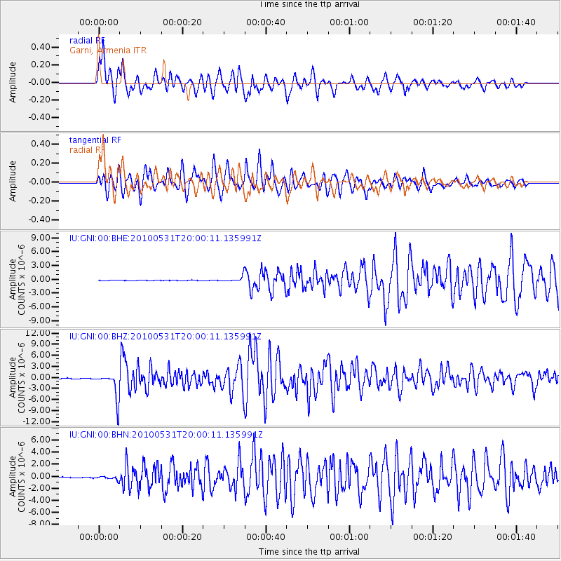
Signal To Noise
| Channel | StoN | STA | LTA |
| IU:GNI:00:BHZ:20100531T20:00:11.135991Z | 47.01905 | 3.815898E-6 | 8.115642E-8 |
| IU:GNI:00:BHN:20100531T20:00:11.135991Z | 3.7848089 | 2.933976E-7 | 7.7519786E-8 |
| IU:GNI:00:BHE:20100531T20:00:11.135991Z | 10.98959 | 6.74473E-7 | 6.1373804E-8 |
| Arrivals |
| Ps | 5.8 SECOND |
| PpPs | 22 SECOND |
| PsPs/PpSs | 28 SECOND |


