You are here: Home > Network List > RV - Regional Alberta Seismic Observatory for Earthquake Studies Network Stations List
> Station YELLA Yellowhead Lookout Tower, AB > Earthquake Result Viewer
YELLA Yellowhead Lookout Tower, AB - Earthquake Result Viewer
| Earthquake location: |
North Atlantic Ocean |
| Earthquake latitude/longitude: |
20.0/-61.1 |
| Earthquake time(UTC): |
2023/07/10 (191) 20:28:25 GMT |
| Earthquake Depth: |
10 km |
| Earthquake Magnitude: |
6.6 mww |
| Earthquake Catalog/Contributor: |
NEIC PDE/us |
|
| Network: |
RV Regional Alberta Seismic Observatory for Earthquake Studies Network |
| Station: |
YELLA Yellowhead Lookout Tower, AB |
| Lat/Lon: |
53.24 N/117.14 W |
| Elevation: |
1478 m |
|
| Distance: |
54.0 deg |
| Az: |
321.959 deg |
| Baz: |
105.422 deg |
| Ray Param: |
0.06571844 |
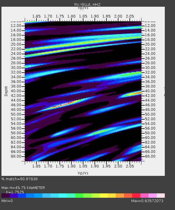
| Estimated Moho Depth: |
45.75 km |
| Estimated Crust Vp/Vs: |
1.75 |
| Assumed Crust Vp: |
6.142 km/s |
| Estimated Crust Vs: |
3.505 km/s |
| Estimated Crust Poisson's Ratio: |
0.26 |
|
| Radial Match: |
90.97638 % |
| Radial Bump: |
400 |
| Transverse Match: |
69.63902 % |
| Transverse Bump: |
400 |
| SOD ConfigId: |
30536071 |
| Insert Time: |
2023-07-24 21:13:59.230 +0000 |
| GWidth: |
2.5 |
| Max Bumps: |
400 |
| Tol: |
0.001 |
|

Signal To Noise
| Channel | StoN | STA | LTA |
| RV:YELLA: :HHZ:20230710T20:37:18.949983Z | 13.74949 | 1.5044817E-6 | 1.0942091E-7 |
| RV:YELLA: :HHN:20230710T20:37:18.949983Z | 1.8674238 | 1.963882E-7 | 1.0516531E-7 |
| RV:YELLA: :HHE:20230710T20:37:18.949983Z | 4.72866 | 4.792715E-7 | 1.013546E-7 |
| Arrivals |
| Ps | 5.9 SECOND |
| PpPs | 20 SECOND |
| PsPs/PpSs | 25 SECOND |


