You are here: Home > Network List > TX - Texas Seismological Network Stations List
> Station DRZT Darrouzett > Earthquake Result Viewer
DRZT Darrouzett - Earthquake Result Viewer
| Earthquake location: |
North Atlantic Ocean |
| Earthquake latitude/longitude: |
20.0/-61.1 |
| Earthquake time(UTC): |
2023/07/10 (191) 20:28:25 GMT |
| Earthquake Depth: |
10 km |
| Earthquake Magnitude: |
6.6 mww |
| Earthquake Catalog/Contributor: |
NEIC PDE/us |
|
| Network: |
TX Texas Seismological Network |
| Station: |
DRZT Darrouzett |
| Lat/Lon: |
36.44 N/100.30 W |
| Elevation: |
791 m |
|
| Distance: |
37.9 deg |
| Az: |
303.98 deg |
| Baz: |
104.759 deg |
| Ray Param: |
0.07586219 |
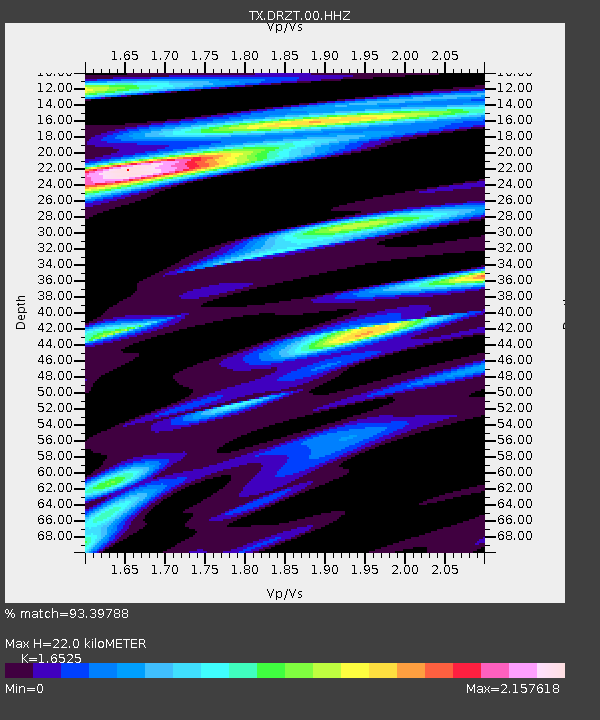
| Estimated Moho Depth: |
22.0 km |
| Estimated Crust Vp/Vs: |
1.65 |
| Assumed Crust Vp: |
6.483 km/s |
| Estimated Crust Vs: |
3.923 km/s |
| Estimated Crust Poisson's Ratio: |
0.21 |
|
| Radial Match: |
93.39788 % |
| Radial Bump: |
400 |
| Transverse Match: |
54.56989 % |
| Transverse Bump: |
400 |
| SOD ConfigId: |
30536071 |
| Insert Time: |
2023-07-24 21:15:11.051 +0000 |
| GWidth: |
2.5 |
| Max Bumps: |
400 |
| Tol: |
0.001 |
|

Signal To Noise
| Channel | StoN | STA | LTA |
| TX:DRZT:00:HHZ:20230710T20:35:12.355013Z | 13.911832 | 1.8465025E-6 | 1.3272893E-7 |
| TX:DRZT:00:HH1:20230710T20:35:12.355013Z | 9.911687 | 9.1404445E-7 | 9.2218855E-8 |
| TX:DRZT:00:HH2:20230710T20:35:12.355013Z | 2.193475 | 2.5174393E-7 | 1.14769456E-7 |
| Arrivals |
| Ps | 2.4 SECOND |
| PpPs | 8.3 SECOND |
| PsPs/PpSs | 11 SECOND |


