You are here: Home > Network List > TX - Texas Seismological Network Stations List
> Station PB01 Permian Basin 1 > Earthquake Result Viewer
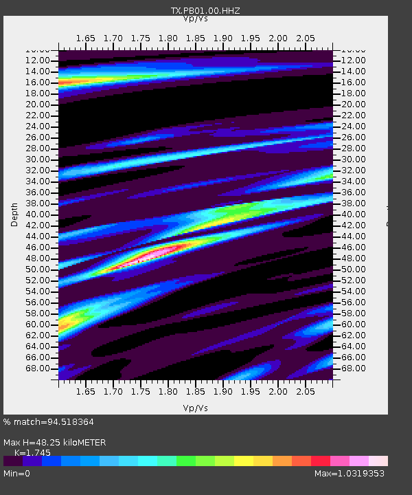
PB01 Permian Basin 1 - Earthquake Result Viewer
| Earthquake location: |
North Atlantic Ocean |
| Earthquake latitude/longitude: |
20.0/-61.1 |
| Earthquake time(UTC): |
2023/07/10 (191) 20:28:25 GMT |
| Earthquake Depth: |
10 km |
| Earthquake Magnitude: |
6.6 mww |
| Earthquake Catalog/Contributor: |
NEIC PDE/us |
|
| Network: |
TX Texas Seismological Network |
| Station: |
PB01 Permian Basin 1 |
| Lat/Lon: |
30.94 N/103.78 W |
| Elevation: |
1010 m |
|
| Distance: |
39.8 deg |
| Az: |
294.558 deg |
| Baz: |
95.489 deg |
| Ray Param: |
0.07475831 |
| Estimated Moho Depth: |
48.25 km |
| Estimated Crust Vp/Vs: |
1.75 |
| Assumed Crust Vp: |
6.121 km/s |
| Estimated Crust Vs: |
3.507 km/s |
| Estimated Crust Poisson's Ratio: |
0.26 |
|
| Radial Match: |
94.518364 % |
| Radial Bump: |
207 |
| Transverse Match: |
74.18604 % |
| Transverse Bump: |
400 |
| SOD ConfigId: |
30536071 |
| Insert Time: |
2023-07-24 21:15:50.421 +0000 |
| GWidth: |
2.5 |
| Max Bumps: |
400 |
| Tol: |
0.001 |
|

Signal To Noise
| Channel | StoN | STA | LTA |
| TX:PB01:00:HHZ:20230710T20:35:28.269991Z | 18.707407 | 1.4085741E-6 | 7.5295E-8 |
| TX:PB01:00:HH1:20230710T20:35:28.269991Z | 2.4077828 | 1.6891607E-7 | 7.01542E-8 |
| TX:PB01:00:HH2:20230710T20:35:28.269991Z | 10.42341 | 9.04881E-7 | 8.681238E-8 |
| Arrivals |
| Ps | 6.3 SECOND |
| PpPs | 20 SECOND |
| PsPs/PpSs | 27 SECOND |


