You are here: Home > Network List > TX - Texas Seismological Network Stations List
> Station PB19 West of Imperial > Earthquake Result Viewer
PB19 West of Imperial - Earthquake Result Viewer
| Earthquake location: |
North Atlantic Ocean |
| Earthquake latitude/longitude: |
20.0/-61.1 |
| Earthquake time(UTC): |
2023/07/10 (191) 20:28:25 GMT |
| Earthquake Depth: |
10 km |
| Earthquake Magnitude: |
6.6 mww |
| Earthquake Catalog/Contributor: |
NEIC PDE/us |
|
| Network: |
TX Texas Seismological Network |
| Station: |
PB19 West of Imperial |
| Lat/Lon: |
31.30 N/103.10 W |
| Elevation: |
782 m |
|
| Distance: |
39.3 deg |
| Az: |
295.212 deg |
| Baz: |
96.344 deg |
| Ray Param: |
0.07509199 |
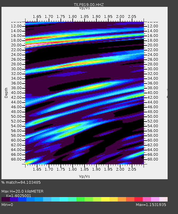
| Estimated Moho Depth: |
20.0 km |
| Estimated Crust Vp/Vs: |
1.60 |
| Assumed Crust Vp: |
6.121 km/s |
| Estimated Crust Vs: |
3.819 km/s |
| Estimated Crust Poisson's Ratio: |
0.18 |
|
| Radial Match: |
94.103485 % |
| Radial Bump: |
400 |
| Transverse Match: |
81.795425 % |
| Transverse Bump: |
400 |
| SOD ConfigId: |
30536071 |
| Insert Time: |
2023-07-24 21:16:22.017 +0000 |
| GWidth: |
2.5 |
| Max Bumps: |
400 |
| Tol: |
0.001 |
|

Signal To Noise
| Channel | StoN | STA | LTA |
| TX:PB19:00:HHZ:20230710T20:35:23.739992Z | 7.6729765 | 2.0481635E-5 | 2.6693208E-6 |
| TX:PB19:00:HHN:20230710T20:35:23.739992Z | 2.3652773 | 6.6224825E-6 | 2.7998756E-6 |
| TX:PB19:00:HHE:20230710T20:35:23.739992Z | 8.672552 | 1.1498049E-5 | 1.3257976E-6 |
| Arrivals |
| Ps | 2.1 SECOND |
| PpPs | 7.9 SECOND |
| PsPs/PpSs | 10 SECOND |


