You are here: Home > Network List > TX - Texas Seismological Network Stations List
> Station PB22 South of Coyonosa > Earthquake Result Viewer
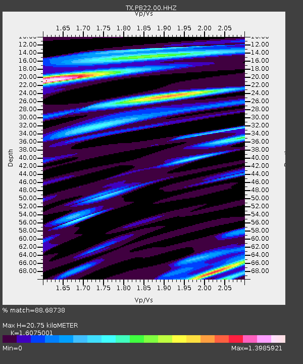
PB22 South of Coyonosa - Earthquake Result Viewer
| Earthquake location: |
North Atlantic Ocean |
| Earthquake latitude/longitude: |
20.0/-61.1 |
| Earthquake time(UTC): |
2023/07/10 (191) 20:28:25 GMT |
| Earthquake Depth: |
10 km |
| Earthquake Magnitude: |
6.6 mww |
| Earthquake Catalog/Contributor: |
NEIC PDE/us |
|
| Network: |
TX Texas Seismological Network |
| Station: |
PB22 South of Coyonosa |
| Lat/Lon: |
31.21 N/103.08 W |
| Elevation: |
808 m |
|
| Distance: |
39.3 deg |
| Az: |
295.073 deg |
| Baz: |
96.248 deg |
| Ray Param: |
0.07510993 |
| Estimated Moho Depth: |
20.75 km |
| Estimated Crust Vp/Vs: |
1.61 |
| Assumed Crust Vp: |
6.121 km/s |
| Estimated Crust Vs: |
3.807 km/s |
| Estimated Crust Poisson's Ratio: |
0.18 |
|
| Radial Match: |
88.68738 % |
| Radial Bump: |
400 |
| Transverse Match: |
51.688797 % |
| Transverse Bump: |
400 |
| SOD ConfigId: |
30536071 |
| Insert Time: |
2023-07-24 21:16:25.428 +0000 |
| GWidth: |
2.5 |
| Max Bumps: |
400 |
| Tol: |
0.001 |
|

Signal To Noise
| Channel | StoN | STA | LTA |
| TX:PB22:00:HHZ:20230710T20:35:23.494997Z | 13.050812 | 2.2802104E-7 | 1.747179E-8 |
| TX:PB22:00:HH1:20230710T20:35:23.494997Z | 0.9053512 | 6.5556655E-8 | 7.2410195E-8 |
| TX:PB22:00:HH2:20230710T20:35:23.494997Z | 2.8327048 | 1.8076393E-7 | 6.381319E-8 |
| Arrivals |
| Ps | 2.2 SECOND |
| PpPs | 8.2 SECOND |
| PsPs/PpSs | 10 SECOND |


