You are here: Home > Network List > UO - University of Oregon Regional Network Stations List
> Station TDWTR Tidewater, OR, USA > Earthquake Result Viewer
TDWTR Tidewater, OR, USA - Earthquake Result Viewer
| Earthquake location: |
North Atlantic Ocean |
| Earthquake latitude/longitude: |
20.0/-61.1 |
| Earthquake time(UTC): |
2023/07/10 (191) 20:28:25 GMT |
| Earthquake Depth: |
10 km |
| Earthquake Magnitude: |
6.6 mww |
| Earthquake Catalog/Contributor: |
NEIC PDE/us |
|
| Network: |
UO University of Oregon Regional Network |
| Station: |
TDWTR Tidewater, OR, USA |
| Lat/Lon: |
44.35 N/123.89 W |
| Elevation: |
594 m |
|
| Distance: |
56.9 deg |
| Az: |
310.42 deg |
| Baz: |
93.787 deg |
| Ray Param: |
0.06381145 |
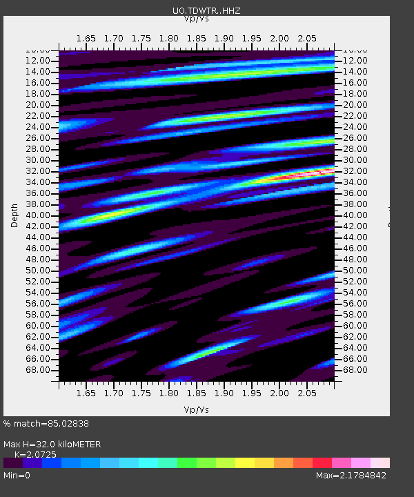
| Estimated Moho Depth: |
32.0 km |
| Estimated Crust Vp/Vs: |
2.07 |
| Assumed Crust Vp: |
6.566 km/s |
| Estimated Crust Vs: |
3.168 km/s |
| Estimated Crust Poisson's Ratio: |
0.35 |
|
| Radial Match: |
85.02838 % |
| Radial Bump: |
400 |
| Transverse Match: |
76.336624 % |
| Transverse Bump: |
400 |
| SOD ConfigId: |
30536071 |
| Insert Time: |
2023-07-24 21:19:06.332 +0000 |
| GWidth: |
2.5 |
| Max Bumps: |
400 |
| Tol: |
0.001 |
|

Signal To Noise
| Channel | StoN | STA | LTA |
| UO:TDWTR: :HHZ:20230710T20:37:39.999971Z | 6.900965 | 9.4757655E-7 | 1.3731072E-7 |
| UO:TDWTR: :HHN:20230710T20:37:39.999971Z | 1.5352224 | 2.78617E-7 | 1.8148313E-7 |
| UO:TDWTR: :HHE:20230710T20:37:39.999971Z | 1.3790658 | 3.1940326E-7 | 2.3160844E-7 |
| Arrivals |
| Ps | 5.5 SECOND |
| PpPs | 14 SECOND |
| PsPs/PpSs | 20 SECOND |


