You are here: Home > Network List > US - United States National Seismic Network Stations List
> Station HDIL Hopedale, Illinois, USA > Earthquake Result Viewer
HDIL Hopedale, Illinois, USA - Earthquake Result Viewer
| Earthquake location: |
North Atlantic Ocean |
| Earthquake latitude/longitude: |
20.0/-61.1 |
| Earthquake time(UTC): |
2023/07/10 (191) 20:28:25 GMT |
| Earthquake Depth: |
10 km |
| Earthquake Magnitude: |
6.6 mww |
| Earthquake Catalog/Contributor: |
NEIC PDE/us |
|
| Network: |
US United States National Seismic Network |
| Station: |
HDIL Hopedale, Illinois, USA |
| Lat/Lon: |
40.56 N/89.29 W |
| Elevation: |
219 m |
|
| Distance: |
31.6 deg |
| Az: |
316.582 deg |
| Baz: |
121.98 deg |
| Ray Param: |
0.07901868 |
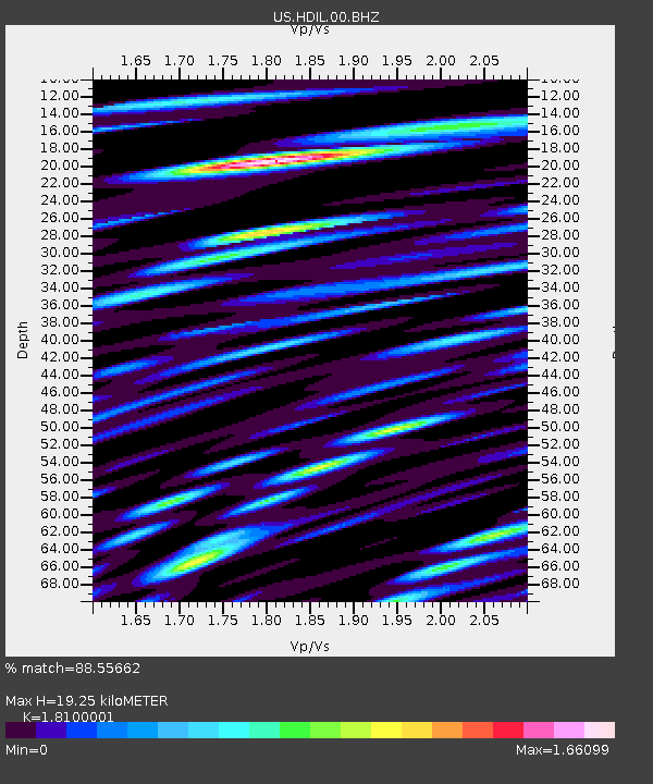
| Estimated Moho Depth: |
19.25 km |
| Estimated Crust Vp/Vs: |
1.81 |
| Assumed Crust Vp: |
6.498 km/s |
| Estimated Crust Vs: |
3.59 km/s |
| Estimated Crust Poisson's Ratio: |
0.28 |
|
| Radial Match: |
88.55662 % |
| Radial Bump: |
400 |
| Transverse Match: |
70.13269 % |
| Transverse Bump: |
400 |
| SOD ConfigId: |
30536071 |
| Insert Time: |
2023-07-24 21:20:23.458 +0000 |
| GWidth: |
2.5 |
| Max Bumps: |
400 |
| Tol: |
0.001 |
|
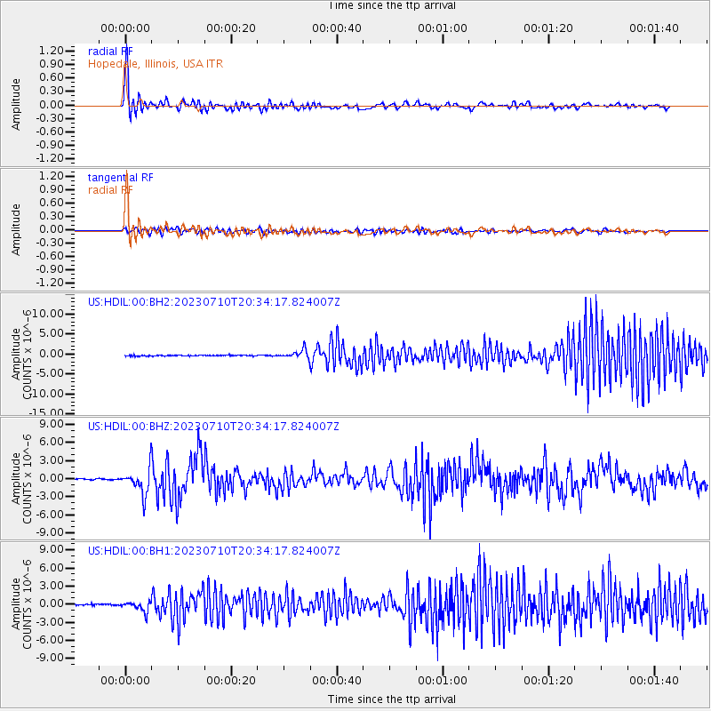
Signal To Noise
| Channel | StoN | STA | LTA |
| US:HDIL:00:BHZ:20230710T20:34:17.824007Z | 28.051695 | 2.1997093E-6 | 7.841628E-8 |
| US:HDIL:00:BH1:20230710T20:34:17.824007Z | 6.098409 | 8.242916E-7 | 1.3516502E-7 |
| US:HDIL:00:BH2:20230710T20:34:17.824007Z | 9.652729 | 1.0518728E-6 | 1.0897155E-7 |
| Arrivals |
| Ps | 2.6 SECOND |
| PpPs | 7.7 SECOND |
| PsPs/PpSs | 10 SECOND |


