You are here: Home > Network List > UW - Pacific Northwest Regional Seismic Network Stations List
> Station LCV Les Collines Vineyard, Walla Walla, WA, USA > Earthquake Result Viewer
LCV Les Collines Vineyard, Walla Walla, WA, USA - Earthquake Result Viewer
| Earthquake location: |
North Atlantic Ocean |
| Earthquake latitude/longitude: |
20.0/-61.1 |
| Earthquake time(UTC): |
2023/07/10 (191) 20:28:25 GMT |
| Earthquake Depth: |
10 km |
| Earthquake Magnitude: |
6.6 mww |
| Earthquake Catalog/Contributor: |
NEIC PDE/us |
|
| Network: |
UW Pacific Northwest Regional Seismic Network |
| Station: |
LCV Les Collines Vineyard, Walla Walla, WA, USA |
| Lat/Lon: |
46.01 N/118.28 W |
| Elevation: |
361 m |
|
| Distance: |
53.2 deg |
| Az: |
312.976 deg |
| Baz: |
99.22 deg |
| Ray Param: |
0.06628329 |
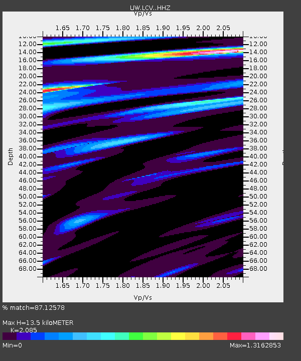
| Estimated Moho Depth: |
13.5 km |
| Estimated Crust Vp/Vs: |
2.09 |
| Assumed Crust Vp: |
6.419 km/s |
| Estimated Crust Vs: |
3.079 km/s |
| Estimated Crust Poisson's Ratio: |
0.35 |
|
| Radial Match: |
87.12578 % |
| Radial Bump: |
400 |
| Transverse Match: |
77.48878 % |
| Transverse Bump: |
400 |
| SOD ConfigId: |
30536071 |
| Insert Time: |
2023-07-24 21:24:18.539 +0000 |
| GWidth: |
2.5 |
| Max Bumps: |
400 |
| Tol: |
0.001 |
|

Signal To Noise
| Channel | StoN | STA | LTA |
| UW:LCV: :HHZ:20230710T20:37:12.920015Z | 10.755999 | 7.70884E-7 | 7.1670144E-8 |
| UW:LCV: :HHN:20230710T20:37:12.920015Z | 2.0694983 | 9.053055E-8 | 4.3745167E-8 |
| UW:LCV: :HHE:20230710T20:37:12.920015Z | 5.8443837 | 2.6892693E-7 | 4.601459E-8 |
| Arrivals |
| Ps | 2.4 SECOND |
| PpPs | 6.2 SECOND |
| PsPs/PpSs | 8.6 SECOND |


