You are here: Home > Network List > UW - Pacific Northwest Regional Seismic Network Stations List
> Station PASS Maple Falls, WA, USA > Earthquake Result Viewer
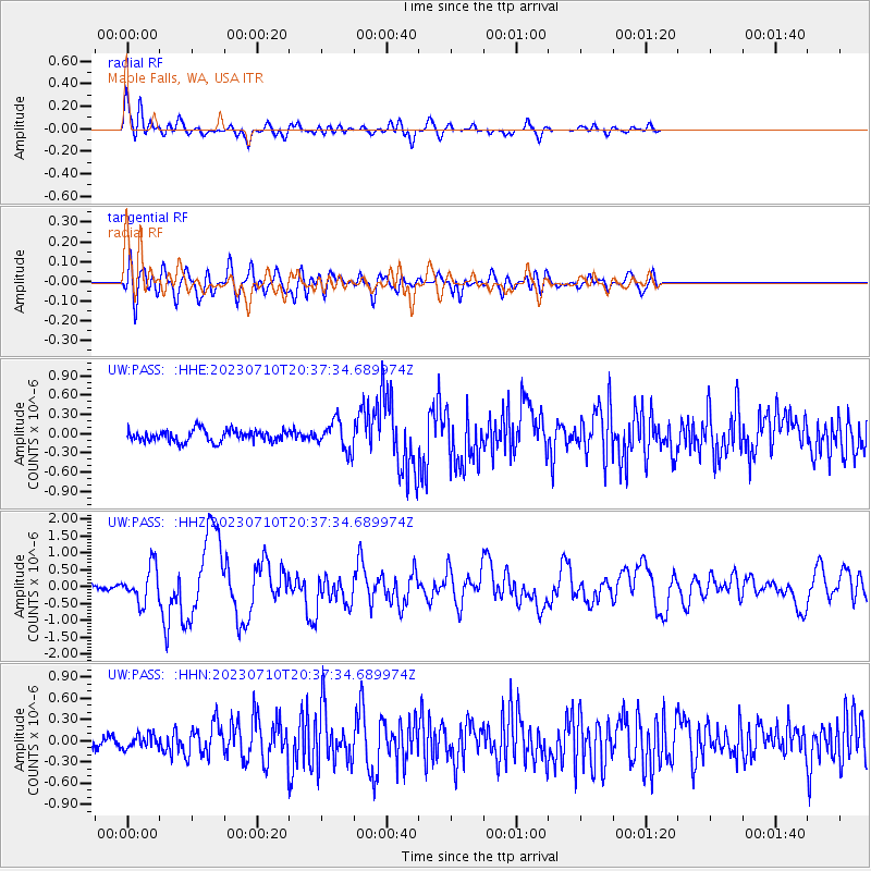
PASS Maple Falls, WA, USA - Earthquake Result Viewer
*The percent match for this event was below the threshold and hence no stack was calculated.
| Earthquake location: |
North Atlantic Ocean |
| Earthquake latitude/longitude: |
20.0/-61.1 |
| Earthquake time(UTC): |
2023/07/10 (191) 20:28:25 GMT |
| Earthquake Depth: |
10 km |
| Earthquake Magnitude: |
6.6 mww |
| Earthquake Catalog/Contributor: |
NEIC PDE/us |
|
| Network: |
UW Pacific Northwest Regional Seismic Network |
| Station: |
PASS Maple Falls, WA, USA |
| Lat/Lon: |
49.00 N/122.09 W |
| Elevation: |
174 m |
|
| Distance: |
56.2 deg |
| Az: |
316.118 deg |
| Baz: |
98.236 deg |
| Ray Param: |
$rayparam |
*The percent match for this event was below the threshold and hence was not used in the summary stack. |
|
| Radial Match: |
78.080376 % |
| Radial Bump: |
400 |
| Transverse Match: |
64.00394 % |
| Transverse Bump: |
400 |
| SOD ConfigId: |
30536071 |
| Insert Time: |
2023-07-24 21:25:25.204 +0000 |
| GWidth: |
2.5 |
| Max Bumps: |
400 |
| Tol: |
0.001 |
|
Signal To Noise
| Channel | StoN | STA | LTA |
| UW:PASS: :HHZ:20230710T20:37:34.689974Z | 7.270657 | 5.3116435E-7 | 7.30559E-8 |
| UW:PASS: :HHN:20230710T20:37:34.689974Z | 1.1152937 | 9.414301E-8 | 8.4410956E-8 |
| UW:PASS: :HHE:20230710T20:37:34.689974Z | 2.4884114 | 2.2590268E-7 | 9.078188E-8 |
| Arrivals |
| Ps | |
| PpPs | |
| PsPs/PpSs | |


