You are here: Home > Network List > UW - Pacific Northwest Regional Seismic Network Stations List
> Station WPEQ White Pass Ski Facility, WA, USA > Earthquake Result Viewer
WPEQ White Pass Ski Facility, WA, USA - Earthquake Result Viewer
| Earthquake location: |
North Atlantic Ocean |
| Earthquake latitude/longitude: |
20.0/-61.1 |
| Earthquake time(UTC): |
2023/07/10 (191) 20:28:25 GMT |
| Earthquake Depth: |
10 km |
| Earthquake Magnitude: |
6.6 mww |
| Earthquake Catalog/Contributor: |
NEIC PDE/us |
|
| Network: |
UW Pacific Northwest Regional Seismic Network |
| Station: |
WPEQ White Pass Ski Facility, WA, USA |
| Lat/Lon: |
46.61 N/121.40 W |
| Elevation: |
1807 m |
|
| Distance: |
55.4 deg |
| Az: |
313.333 deg |
| Baz: |
97.173 deg |
| Ray Param: |
0.06480699 |
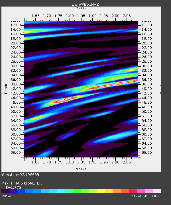
| Estimated Moho Depth: |
44.5 km |
| Estimated Crust Vp/Vs: |
1.77 |
| Assumed Crust Vp: |
6.597 km/s |
| Estimated Crust Vs: |
3.717 km/s |
| Estimated Crust Poisson's Ratio: |
0.27 |
|
| Radial Match: |
93.198685 % |
| Radial Bump: |
400 |
| Transverse Match: |
83.479866 % |
| Transverse Bump: |
400 |
| SOD ConfigId: |
30536071 |
| Insert Time: |
2023-07-24 21:26:51.937 +0000 |
| GWidth: |
2.5 |
| Max Bumps: |
400 |
| Tol: |
0.001 |
|

Signal To Noise
| Channel | StoN | STA | LTA |
| UW:WPEQ: :HHZ:20230710T20:37:29.139986Z | 13.643548 | 7.982012E-7 | 5.8503932E-8 |
| UW:WPEQ: :HHN:20230710T20:37:29.139986Z | 1.4862953 | 1.06563746E-7 | 7.1697556E-8 |
| UW:WPEQ: :HHE:20230710T20:37:29.139986Z | 3.6011581 | 4.3777266E-7 | 1.2156441E-7 |
| Arrivals |
| Ps | 5.5 SECOND |
| PpPs | 18 SECOND |
| PsPs/PpSs | 23 SECOND |


