You are here: Home > Network List > AK - Alaska Regional Network Stations List
> Station H23K Yukon River, AK, USA > Earthquake Result Viewer
H23K Yukon River, AK, USA - Earthquake Result Viewer
| Earthquake location: |
Near Coast Of Chiapas, Mexico |
| Earthquake latitude/longitude: |
15.0/-93.9 |
| Earthquake time(UTC): |
2023/07/14 (195) 09:29:01 GMT |
| Earthquake Depth: |
35 km |
| Earthquake Magnitude: |
6.3 mww |
| Earthquake Catalog/Contributor: |
NEIC PDE/us |
|
| Network: |
AK Alaska Regional Network |
| Station: |
H23K Yukon River, AK, USA |
| Lat/Lon: |
65.83 N/149.54 W |
| Elevation: |
617 m |
|
| Distance: |
62.7 deg |
| Az: |
337.49 deg |
| Baz: |
116.076 deg |
| Ray Param: |
0.06002204 |
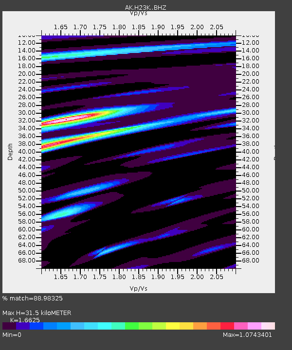
| Estimated Moho Depth: |
31.5 km |
| Estimated Crust Vp/Vs: |
1.66 |
| Assumed Crust Vp: |
6.566 km/s |
| Estimated Crust Vs: |
3.95 km/s |
| Estimated Crust Poisson's Ratio: |
0.22 |
|
| Radial Match: |
88.98325 % |
| Radial Bump: |
318 |
| Transverse Match: |
77.632256 % |
| Transverse Bump: |
400 |
| SOD ConfigId: |
30536071 |
| Insert Time: |
2023-07-28 09:34:19.442 +0000 |
| GWidth: |
2.5 |
| Max Bumps: |
400 |
| Tol: |
0.001 |
|

Signal To Noise
| Channel | StoN | STA | LTA |
| AK:H23K: :BHZ:20230714T09:38:51.640029Z | 65.714096 | 2.6813602E-6 | 4.0803425E-8 |
| AK:H23K: :BHN:20230714T09:38:51.640029Z | 16.870457 | 5.748323E-7 | 3.4073313E-8 |
| AK:H23K: :BHE:20230714T09:38:51.640029Z | 32.062263 | 1.0828659E-6 | 3.3773844E-8 |
| Arrivals |
| Ps | 3.3 SECOND |
| PpPs | 12 SECOND |
| PsPs/PpSs | 15 SECOND |


