You are here: Home > Network List > AV - Alaska Volcano Observatory Stations List
> Station AMKA Regional Station, Amchitka Island, Alaska > Earthquake Result Viewer
AMKA Regional Station, Amchitka Island, Alaska - Earthquake Result Viewer
| Earthquake location: |
Near Coast Of Chiapas, Mexico |
| Earthquake latitude/longitude: |
15.0/-93.9 |
| Earthquake time(UTC): |
2023/07/14 (195) 09:29:01 GMT |
| Earthquake Depth: |
35 km |
| Earthquake Magnitude: |
6.3 mww |
| Earthquake Catalog/Contributor: |
NEIC PDE/us |
|
| Network: |
AV Alaska Volcano Observatory |
| Station: |
AMKA Regional Station, Amchitka Island, Alaska |
| Lat/Lon: |
51.38 N/179.30 E |
| Elevation: |
116 m |
|
| Distance: |
76.4 deg |
| Az: |
319.931 deg |
| Baz: |
82.921 deg |
| Ray Param: |
0.050949346 |
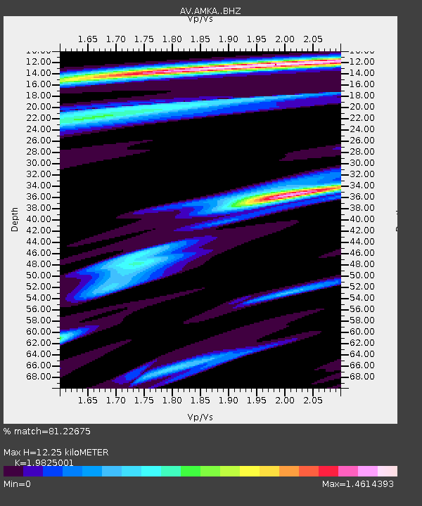
| Estimated Moho Depth: |
12.25 km |
| Estimated Crust Vp/Vs: |
1.98 |
| Assumed Crust Vp: |
6.183 km/s |
| Estimated Crust Vs: |
3.119 km/s |
| Estimated Crust Poisson's Ratio: |
0.33 |
|
| Radial Match: |
81.22675 % |
| Radial Bump: |
400 |
| Transverse Match: |
77.593506 % |
| Transverse Bump: |
400 |
| SOD ConfigId: |
30536071 |
| Insert Time: |
2023-07-28 09:37:19.267 +0000 |
| GWidth: |
2.5 |
| Max Bumps: |
400 |
| Tol: |
0.001 |
|
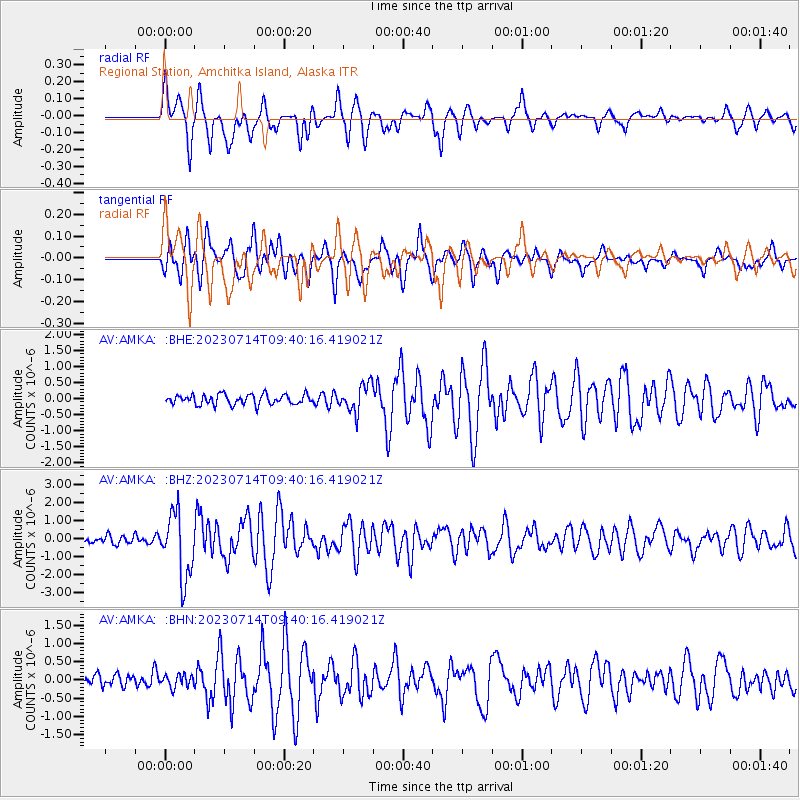
Signal To Noise
| Channel | StoN | STA | LTA |
| AV:AMKA: :BHZ:20230714T09:40:16.419021Z | 8.401926 | 1.8299562E-6 | 2.17802E-7 |
| AV:AMKA: :BHN:20230714T09:40:16.419021Z | 0.8284528 | 1.7255044E-7 | 2.0828035E-7 |
| AV:AMKA: :BHE:20230714T09:40:16.419021Z | 2.8466904 | 4.4032822E-7 | 1.5468075E-7 |
| Arrivals |
| Ps | 2.0 SECOND |
| PpPs | 5.8 SECOND |
| PsPs/PpSs | 7.8 SECOND |


