You are here: Home > Network List > AV - Alaska Volcano Observatory Stations List
> Station AUJK Augustine Jurgen Kienle, Cook Inlet, Alaska > Earthquake Result Viewer
AUJK Augustine Jurgen Kienle, Cook Inlet, Alaska - Earthquake Result Viewer
| Earthquake location: |
Near Coast Of Chiapas, Mexico |
| Earthquake latitude/longitude: |
15.0/-93.9 |
| Earthquake time(UTC): |
2023/07/14 (195) 09:29:01 GMT |
| Earthquake Depth: |
35 km |
| Earthquake Magnitude: |
6.3 mww |
| Earthquake Catalog/Contributor: |
NEIC PDE/us |
|
| Network: |
AV Alaska Volcano Observatory |
| Station: |
AUJK Augustine Jurgen Kienle, Cook Inlet, Alaska |
| Lat/Lon: |
59.35 N/153.41 W |
| Elevation: |
377 m |
|
| Distance: |
61.8 deg |
| Az: |
329.933 deg |
| Baz: |
109.117 deg |
| Ray Param: |
0.060579244 |
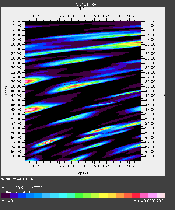
| Estimated Moho Depth: |
48.0 km |
| Estimated Crust Vp/Vs: |
1.61 |
| Assumed Crust Vp: |
5.989 km/s |
| Estimated Crust Vs: |
3.714 km/s |
| Estimated Crust Poisson's Ratio: |
0.19 |
|
| Radial Match: |
81.094 % |
| Radial Bump: |
400 |
| Transverse Match: |
64.84081 % |
| Transverse Bump: |
400 |
| SOD ConfigId: |
30536071 |
| Insert Time: |
2023-07-28 09:37:37.164 +0000 |
| GWidth: |
2.5 |
| Max Bumps: |
400 |
| Tol: |
0.001 |
|
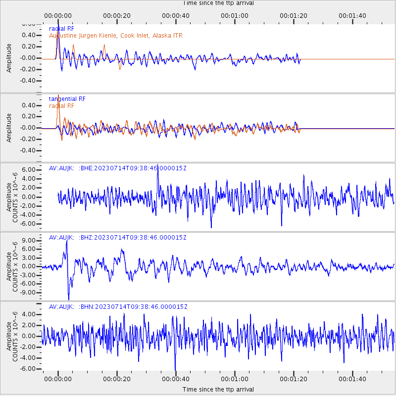
Signal To Noise
| Channel | StoN | STA | LTA |
| AV:AUJK: :BHZ:20230714T09:38:46.000015Z | 10.191645 | 4.6287455E-6 | 4.541706E-7 |
| AV:AUJK: :BHN:20230714T09:38:46.000015Z | 1.1388558 | 1.1005014E-6 | 9.663221E-7 |
| AV:AUJK: :BHE:20230714T09:38:46.000015Z | 2.1660523 | 2.336454E-6 | 1.0786691E-6 |
| Arrivals |
| Ps | 5.1 SECOND |
| PpPs | 20 SECOND |
| PsPs/PpSs | 25 SECOND |


