You are here: Home > Network List > AV - Alaska Volcano Observatory Stations List
> Station GSIG Igitkin Island, Great Sitkin Volcano, Alaska > Earthquake Result Viewer
GSIG Igitkin Island, Great Sitkin Volcano, Alaska - Earthquake Result Viewer

| Earthquake location: |
Near Coast Of Chiapas, Mexico |
| Earthquake latitude/longitude: |
15.0/-93.9 |
| Earthquake time(UTC): |
2023/07/14 (195) 09:29:01 GMT |
| Earthquake Depth: |
35 km |
| Earthquake Magnitude: |
6.3 mww |
| Earthquake Catalog/Contributor: |
NEIC PDE/us |
|
| Network: |
AV Alaska Volcano Observatory |
| Station: |
GSIG Igitkin Island, Great Sitkin Volcano, Alaska |
| Lat/Lon: |
51.99 N/175.93 W |
| Elevation: |
407 m |
|
| Distance: |
73.4 deg |
| Az: |
320.281 deg |
| Baz: |
86.747 deg |
| Ray Param: |
0.052960273 |
| Estimated Moho Depth: |
21.5 km |
| Estimated Crust Vp/Vs: |
1.77 |
| Assumed Crust Vp: |
3.943 km/s |
| Estimated Crust Vs: |
2.222 km/s |
| Estimated Crust Poisson's Ratio: |
0.27 |
|
| Radial Match: |
81.11846 % |
| Radial Bump: |
400 |
| Transverse Match: |
62.438797 % |
| Transverse Bump: |
400 |
| SOD ConfigId: |
30536071 |
| Insert Time: |
2023-07-28 09:38:26.351 +0000 |
| GWidth: |
2.5 |
| Max Bumps: |
400 |
| Tol: |
0.001 |
|
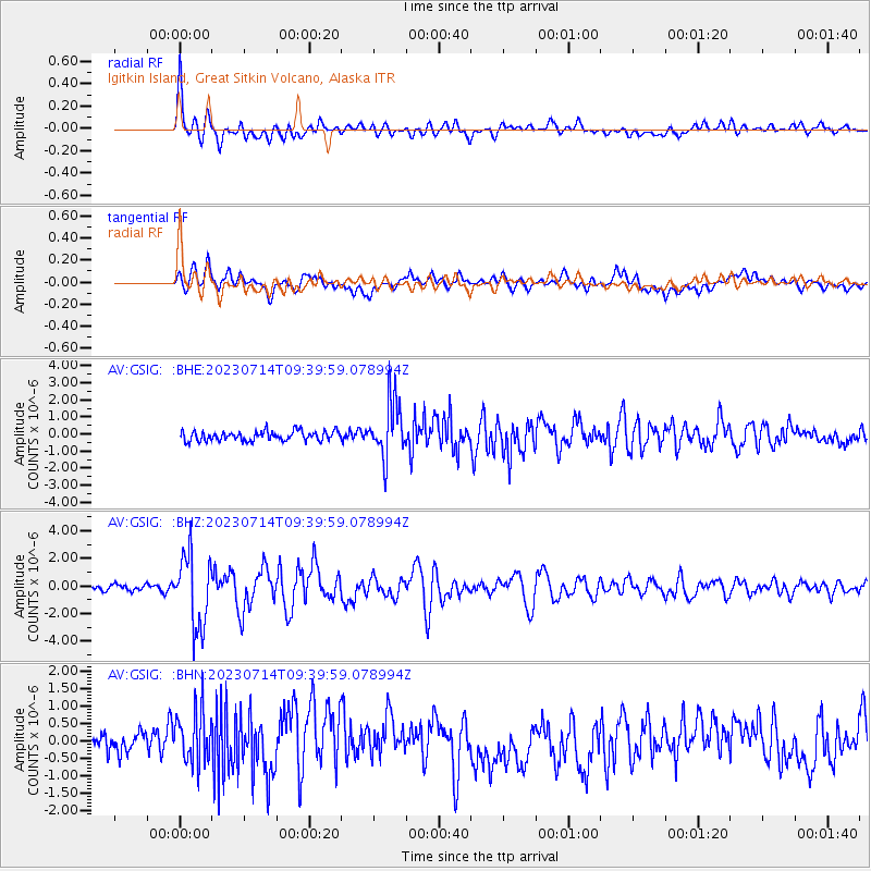
Signal To Noise
| Channel | StoN | STA | LTA |
| AV:GSIG: :BHZ:20230714T09:39:59.078994Z | 8.673059 | 2.6194E-6 | 3.0201568E-7 |
| AV:GSIG: :BHN:20230714T09:39:59.078994Z | 1.7693335 | 7.9703324E-7 | 4.5047088E-7 |
| AV:GSIG: :BHE:20230714T09:39:59.078994Z | 5.72185 | 1.6298873E-6 | 2.848532E-7 |
| Arrivals |
| Ps | 4.3 SECOND |
| PpPs | 15 SECOND |
| PsPs/PpSs | 19 SECOND |


