You are here: Home > Network List > AV - Alaska Volcano Observatory Stations List
> Station KAB2 Katmai Barrier Ridge Two, Alaska > Earthquake Result Viewer
KAB2 Katmai Barrier Ridge Two, Alaska - Earthquake Result Viewer
| Earthquake location: |
Near Coast Of Chiapas, Mexico |
| Earthquake latitude/longitude: |
15.0/-93.9 |
| Earthquake time(UTC): |
2023/07/14 (195) 09:29:01 GMT |
| Earthquake Depth: |
35 km |
| Earthquake Magnitude: |
6.3 mww |
| Earthquake Catalog/Contributor: |
NEIC PDE/us |
|
| Network: |
AV Alaska Volcano Observatory |
| Station: |
KAB2 Katmai Barrier Ridge Two, Alaska |
| Lat/Lon: |
58.13 N/154.98 W |
| Elevation: |
908 m |
|
| Distance: |
62.2 deg |
| Az: |
328.331 deg |
| Baz: |
107.029 deg |
| Ray Param: |
0.060320534 |
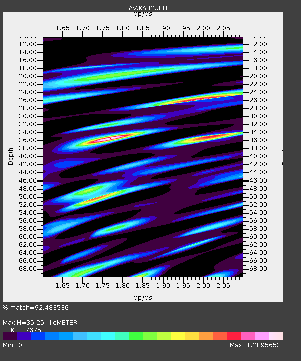
| Estimated Moho Depth: |
35.25 km |
| Estimated Crust Vp/Vs: |
1.77 |
| Assumed Crust Vp: |
6.438 km/s |
| Estimated Crust Vs: |
3.643 km/s |
| Estimated Crust Poisson's Ratio: |
0.26 |
|
| Radial Match: |
92.483536 % |
| Radial Bump: |
400 |
| Transverse Match: |
78.16217 % |
| Transverse Bump: |
400 |
| SOD ConfigId: |
30536071 |
| Insert Time: |
2023-07-28 09:38:43.914 +0000 |
| GWidth: |
2.5 |
| Max Bumps: |
400 |
| Tol: |
0.001 |
|

Signal To Noise
| Channel | StoN | STA | LTA |
| AV:KAB2: :BHZ:20230714T09:38:48.659988Z | 45.513683 | 2.88745E-6 | 6.3441355E-8 |
| AV:KAB2: :BHN:20230714T09:38:48.659988Z | 9.34786 | 1.113267E-6 | 1.1909324E-7 |
| AV:KAB2: :BHE:20230714T09:38:48.659988Z | 13.010044 | 1.6640512E-6 | 1.2790511E-7 |
| Arrivals |
| Ps | 4.4 SECOND |
| PpPs | 14 SECOND |
| PsPs/PpSs | 19 SECOND |


