You are here: Home > Network List > AV - Alaska Volcano Observatory Stations List
> Station KARR Katmai Rainbow River, Alaska > Earthquake Result Viewer
KARR Katmai Rainbow River, Alaska - Earthquake Result Viewer
| Earthquake location: |
Near Coast Of Chiapas, Mexico |
| Earthquake latitude/longitude: |
15.0/-93.9 |
| Earthquake time(UTC): |
2023/07/14 (195) 09:29:01 GMT |
| Earthquake Depth: |
35 km |
| Earthquake Magnitude: |
6.3 mww |
| Earthquake Catalog/Contributor: |
NEIC PDE/us |
|
| Network: |
AV Alaska Volcano Observatory |
| Station: |
KARR Katmai Rainbow River, Alaska |
| Lat/Lon: |
58.50 N/154.71 W |
| Elevation: |
610 m |
|
| Distance: |
62.2 deg |
| Az: |
328.775 deg |
| Baz: |
107.466 deg |
| Ray Param: |
0.060339037 |
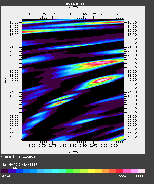
| Estimated Moho Depth: |
40.0 km |
| Estimated Crust Vp/Vs: |
1.99 |
| Assumed Crust Vp: |
6.438 km/s |
| Estimated Crust Vs: |
3.235 km/s |
| Estimated Crust Poisson's Ratio: |
0.33 |
|
| Radial Match: |
81.665504 % |
| Radial Bump: |
400 |
| Transverse Match: |
74.48137 % |
| Transverse Bump: |
400 |
| SOD ConfigId: |
30536071 |
| Insert Time: |
2023-07-28 09:38:51.016 +0000 |
| GWidth: |
2.5 |
| Max Bumps: |
400 |
| Tol: |
0.001 |
|
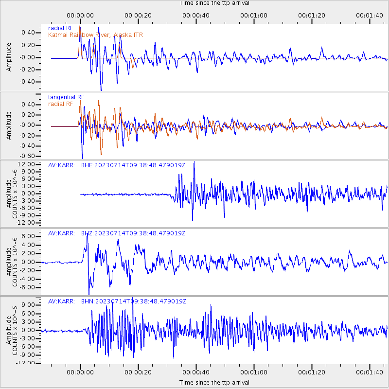
Signal To Noise
| Channel | StoN | STA | LTA |
| AV:KARR: :BHZ:20230714T09:38:48.479019Z | 36.177544 | 3.6395168E-6 | 1.0060154E-7 |
| AV:KARR: :BHN:20230714T09:38:48.479019Z | 16.027348 | 2.257147E-6 | 1.4083098E-7 |
| AV:KARR: :BHE:20230714T09:38:48.479019Z | 17.647648 | 2.6118194E-6 | 1.4799816E-7 |
| Arrivals |
| Ps | 6.4 SECOND |
| PpPs | 18 SECOND |
| PsPs/PpSs | 24 SECOND |


