You are here: Home > Network List > CI - Caltech Regional Seismic Network Stations List
> Station LGU LGU, Camarillo, CA, USA > Earthquake Result Viewer
LGU LGU, Camarillo, CA, USA - Earthquake Result Viewer
| Earthquake location: |
Costa Rica |
| Earthquake latitude/longitude: |
9.3/-84.2 |
| Earthquake time(UTC): |
2010/06/01 (152) 03:26:15 GMT |
| Earthquake Depth: |
18 km |
| Earthquake Magnitude: |
5.7 MB, 5.6 MS, 6.0 MW, 5.9 MW |
| Earthquake Catalog/Contributor: |
WHDF/NEIC |
|
| Network: |
CI Caltech Regional Seismic Network |
| Station: |
LGU LGU, Camarillo, CA, USA |
| Lat/Lon: |
34.11 N/119.07 W |
| Elevation: |
416 m |
|
| Distance: |
40.4 deg |
| Az: |
312.934 deg |
| Baz: |
119.44 deg |
| Ray Param: |
0.0744195 |
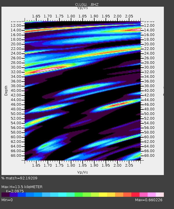
| Estimated Moho Depth: |
13.5 km |
| Estimated Crust Vp/Vs: |
2.10 |
| Assumed Crust Vp: |
6.1 km/s |
| Estimated Crust Vs: |
2.908 km/s |
| Estimated Crust Poisson's Ratio: |
0.35 |
|
| Radial Match: |
92.19209 % |
| Radial Bump: |
400 |
| Transverse Match: |
80.58384 % |
| Transverse Bump: |
400 |
| SOD ConfigId: |
317696 |
| Insert Time: |
2010-09-19 06:51:50.028 +0000 |
| GWidth: |
2.5 |
| Max Bumps: |
400 |
| Tol: |
0.001 |
|
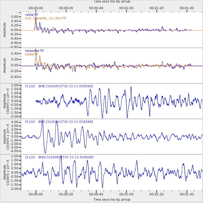
Signal To Noise
| Channel | StoN | STA | LTA |
| CI:LGU: :BHZ:20100601T03:33:21.638998Z | 6.4725266 | 1.7836467E-6 | 2.7557192E-7 |
| CI:LGU: :BHN:20100601T03:33:21.638998Z | 2.1763747 | 4.866967E-7 | 2.2362727E-7 |
| CI:LGU: :BHE:20100601T03:33:21.638998Z | 2.2513342 | 6.972268E-7 | 3.0969494E-7 |
| Arrivals |
| Ps | 2.6 SECOND |
| PpPs | 6.5 SECOND |
| PsPs/PpSs | 9.1 SECOND |


