You are here: Home > Network List > PF - Volcanologic Network of Piton de Fournaise-OVPF Stations List
> Station HIM cratere Himiltrude > Earthquake Result Viewer
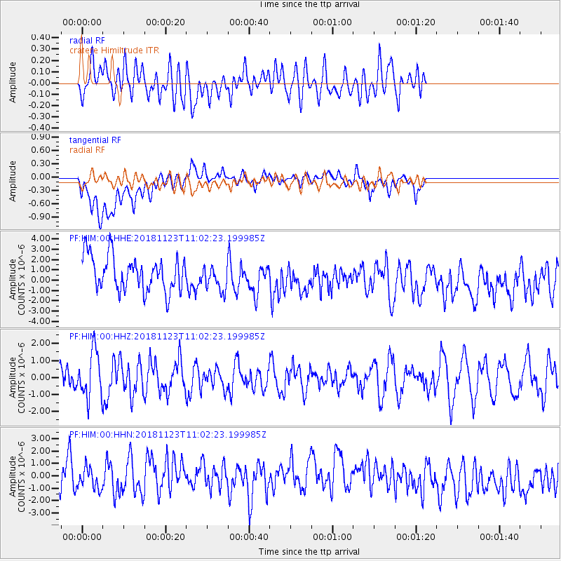
HIM cratere Himiltrude - Earthquake Result Viewer
*The percent match for this event was below the threshold and hence no stack was calculated.
| Earthquake location: |
South Sandwich Islands Region |
| Earthquake latitude/longitude: |
-56.3/-27.0 |
| Earthquake time(UTC): |
2018/11/23 (327) 10:51:59 GMT |
| Earthquake Depth: |
83 km |
| Earthquake Magnitude: |
5.6 mb |
| Earthquake Catalog/Contributor: |
NEIC PDE/us |
|
| Network: |
PF Volcanologic Network of Piton de Fournaise-OVPF |
| Station: |
HIM cratere Himiltrude |
| Lat/Lon: |
21.21 S/55.72 E |
| Elevation: |
1958 m |
|
| Distance: |
68.6 deg |
| Az: |
96.313 deg |
| Baz: |
216.468 deg |
| Ray Param: |
$rayparam |
*The percent match for this event was below the threshold and hence was not used in the summary stack. |
|
| Radial Match: |
60.615395 % |
| Radial Bump: |
400 |
| Transverse Match: |
49.632744 % |
| Transverse Bump: |
400 |
| SOD ConfigId: |
3165032 |
| Insert Time: |
2018-12-07 11:05:54.874 +0000 |
| GWidth: |
2.5 |
| Max Bumps: |
400 |
| Tol: |
0.001 |
|
Signal To Noise
| Channel | StoN | STA | LTA |
| PF:HIM:00:HHZ:20181123T11:02:23.199985Z | 1.58346 | 1.3715494E-6 | 8.6617246E-7 |
| PF:HIM:00:HHN:20181123T11:02:23.199985Z | 0.50352883 | 8.885162E-7 | 1.7645785E-6 |
| PF:HIM:00:HHE:20181123T11:02:23.199985Z | 0.74964565 | 1.2484352E-6 | 1.665367E-6 |
| Arrivals |
| Ps | |
| PpPs | |
| PsPs/PpSs | |


