You are here: Home > Network List > AV - Alaska Volcano Observatory Stations List
> Station VNKR Kametolook River, Mount Veniaminof, Alaska > Earthquake Result Viewer
VNKR Kametolook River, Mount Veniaminof, Alaska - Earthquake Result Viewer
| Earthquake location: |
Near Coast Of Chiapas, Mexico |
| Earthquake latitude/longitude: |
15.0/-93.9 |
| Earthquake time(UTC): |
2023/07/14 (195) 09:29:01 GMT |
| Earthquake Depth: |
35 km |
| Earthquake Magnitude: |
6.3 mww |
| Earthquake Catalog/Contributor: |
NEIC PDE/us |
|
| Network: |
AV Alaska Volcano Observatory |
| Station: |
VNKR Kametolook River, Mount Veniaminof, Alaska |
| Lat/Lon: |
56.03 N/159.37 W |
| Elevation: |
620 m |
|
| Distance: |
64.0 deg |
| Az: |
325.371 deg |
| Baz: |
102.008 deg |
| Ray Param: |
0.0591487 |
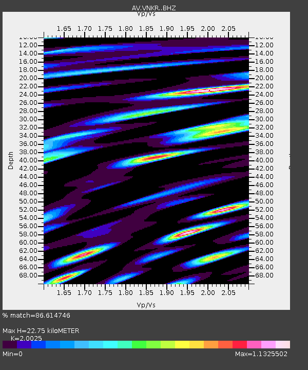
| Estimated Moho Depth: |
22.75 km |
| Estimated Crust Vp/Vs: |
2.00 |
| Assumed Crust Vp: |
6.134 km/s |
| Estimated Crust Vs: |
3.063 km/s |
| Estimated Crust Poisson's Ratio: |
0.33 |
|
| Radial Match: |
86.614746 % |
| Radial Bump: |
400 |
| Transverse Match: |
87.07793 % |
| Transverse Bump: |
400 |
| SOD ConfigId: |
30536071 |
| Insert Time: |
2023-07-28 09:40:51.983 +0000 |
| GWidth: |
2.5 |
| Max Bumps: |
400 |
| Tol: |
0.001 |
|

Signal To Noise
| Channel | StoN | STA | LTA |
| AV:VNKR: :BHZ:20230714T09:39:00.539016Z | 23.545673 | 3.2804342E-6 | 1.3932215E-7 |
| AV:VNKR: :BHN:20230714T09:39:00.539016Z | 4.271176 | 6.986736E-7 | 1.6357875E-7 |
| AV:VNKR: :BHE:20230714T09:39:00.539016Z | 5.850873 | 1.2557598E-6 | 2.1462778E-7 |
| Arrivals |
| Ps | 3.8 SECOND |
| PpPs | 11 SECOND |
| PsPs/PpSs | 15 SECOND |


