You are here: Home > Network List > CC - Cascade Chain Volcano Monitoring Stations List
> Station SWNB Southwest Newberry, Newberry Volcano > Earthquake Result Viewer
SWNB Southwest Newberry, Newberry Volcano - Earthquake Result Viewer
| Earthquake location: |
Near Coast Of Chiapas, Mexico |
| Earthquake latitude/longitude: |
15.0/-93.9 |
| Earthquake time(UTC): |
2023/07/14 (195) 09:29:01 GMT |
| Earthquake Depth: |
35 km |
| Earthquake Magnitude: |
6.3 mww |
| Earthquake Catalog/Contributor: |
NEIC PDE/us |
|
| Network: |
CC Cascade Chain Volcano Monitoring |
| Station: |
SWNB Southwest Newberry, Newberry Volcano |
| Lat/Lon: |
43.67 N/121.36 W |
| Elevation: |
1569 m |
|
| Distance: |
36.9 deg |
| Az: |
326.136 deg |
| Baz: |
132.099 deg |
| Ray Param: |
0.07636822 |
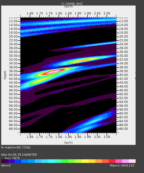
| Estimated Moho Depth: |
38.25 km |
| Estimated Crust Vp/Vs: |
1.77 |
| Assumed Crust Vp: |
6.597 km/s |
| Estimated Crust Vs: |
3.733 km/s |
| Estimated Crust Poisson's Ratio: |
0.26 |
|
| Radial Match: |
88.72361 % |
| Radial Bump: |
278 |
| Transverse Match: |
69.4266 % |
| Transverse Bump: |
400 |
| SOD ConfigId: |
30536071 |
| Insert Time: |
2023-07-28 09:44:30.010 +0000 |
| GWidth: |
2.5 |
| Max Bumps: |
400 |
| Tol: |
0.001 |
|

Signal To Noise
| Channel | StoN | STA | LTA |
| CC:SWNB: :BHZ:20230714T09:35:36.580001Z | 45.200623 | 2.4131252E-6 | 5.338699E-8 |
| CC:SWNB: :BHN:20230714T09:35:36.580001Z | 12.681593 | 7.2074505E-7 | 5.683395E-8 |
| CC:SWNB: :BHE:20230714T09:35:36.580001Z | 10.71828 | 8.184047E-7 | 7.635598E-8 |
| Arrivals |
| Ps | 4.8 SECOND |
| PpPs | 15 SECOND |
| PsPs/PpSs | 20 SECOND |


