You are here: Home > Network List > CN - Canadian National Seismograph Network Stations List
> Station GOBB Galiano Island, BC, CA > Earthquake Result Viewer
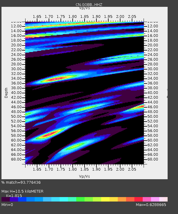
GOBB Galiano Island, BC, CA - Earthquake Result Viewer
| Earthquake location: |
Near Coast Of Chiapas, Mexico |
| Earthquake latitude/longitude: |
15.0/-93.9 |
| Earthquake time(UTC): |
2023/07/14 (195) 09:29:01 GMT |
| Earthquake Depth: |
35 km |
| Earthquake Magnitude: |
6.3 mww |
| Earthquake Catalog/Contributor: |
NEIC PDE/us |
|
| Network: |
CN Canadian National Seismograph Network |
| Station: |
GOBB Galiano Island, BC, CA |
| Lat/Lon: |
48.95 N/123.51 W |
| Elevation: |
143 m |
|
| Distance: |
41.6 deg |
| Az: |
330.615 deg |
| Baz: |
134.014 deg |
| Ray Param: |
0.07359988 |
| Estimated Moho Depth: |
10.5 km |
| Estimated Crust Vp/Vs: |
1.82 |
| Assumed Crust Vp: |
6.566 km/s |
| Estimated Crust Vs: |
3.618 km/s |
| Estimated Crust Poisson's Ratio: |
0.28 |
|
| Radial Match: |
93.776436 % |
| Radial Bump: |
345 |
| Transverse Match: |
83.125435 % |
| Transverse Bump: |
400 |
| SOD ConfigId: |
30536071 |
| Insert Time: |
2023-07-28 09:46:42.233 +0000 |
| GWidth: |
2.5 |
| Max Bumps: |
400 |
| Tol: |
0.001 |
|

Signal To Noise
| Channel | StoN | STA | LTA |
| CN:GOBB: :HHZ:20230714T09:36:15.710006Z | 55.489185 | 4.2636193E-6 | 7.683695E-8 |
| CN:GOBB: :HHN:20230714T09:36:15.710006Z | 12.977238 | 1.6298188E-6 | 1.2559057E-7 |
| CN:GOBB: :HHE:20230714T09:36:15.710006Z | 10.670181 | 1.0290792E-6 | 9.6444396E-8 |
| Arrivals |
| Ps | 1.4 SECOND |
| PpPs | 4.2 SECOND |
| PsPs/PpSs | 5.6 SECOND |


