You are here: Home > Network List > CN - Canadian National Seismograph Network Stations List
> Station PNPO PUKASKWA, ON > Earthquake Result Viewer
PNPO PUKASKWA, ON - Earthquake Result Viewer
| Earthquake location: |
Near Coast Of Chiapas, Mexico |
| Earthquake latitude/longitude: |
15.0/-93.9 |
| Earthquake time(UTC): |
2023/07/14 (195) 09:29:01 GMT |
| Earthquake Depth: |
35 km |
| Earthquake Magnitude: |
6.3 mww |
| Earthquake Catalog/Contributor: |
NEIC PDE/us |
|
| Network: |
CN Canadian National Seismograph Network |
| Station: |
PNPO PUKASKWA, ON |
| Lat/Lon: |
48.60 N/86.28 W |
| Elevation: |
219 m |
|
| Distance: |
34.0 deg |
| Az: |
9.014 deg |
| Baz: |
193.18 deg |
| Ray Param: |
0.0778759 |
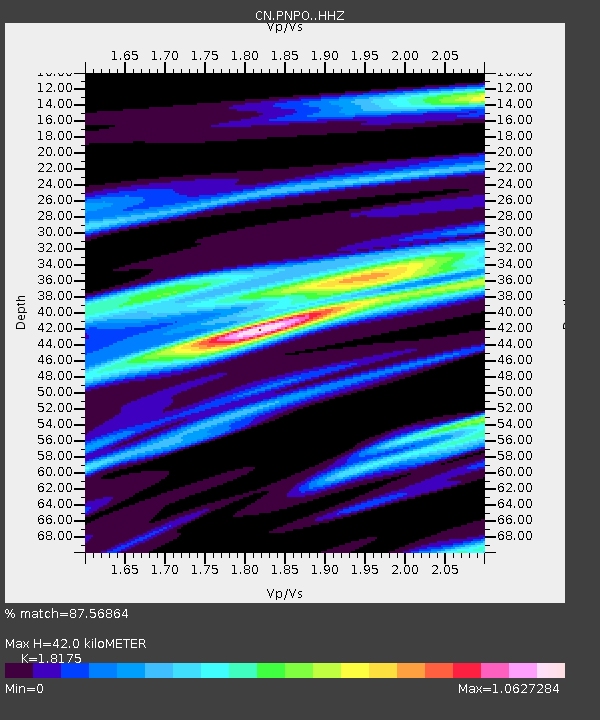
| Estimated Moho Depth: |
42.0 km |
| Estimated Crust Vp/Vs: |
1.82 |
| Assumed Crust Vp: |
6.472 km/s |
| Estimated Crust Vs: |
3.561 km/s |
| Estimated Crust Poisson's Ratio: |
0.28 |
|
| Radial Match: |
87.56864 % |
| Radial Bump: |
256 |
| Transverse Match: |
70.91832 % |
| Transverse Bump: |
400 |
| SOD ConfigId: |
30536071 |
| Insert Time: |
2023-07-28 09:47:38.133 +0000 |
| GWidth: |
2.5 |
| Max Bumps: |
400 |
| Tol: |
0.001 |
|

Signal To Noise
| Channel | StoN | STA | LTA |
| CN:PNPO: :HHZ:20230714T09:35:11.879989Z | 33.979446 | 2.5690158E-6 | 7.5604994E-8 |
| CN:PNPO: :HHN:20230714T09:35:11.879989Z | 22.719126 | 1.5093633E-6 | 6.64358E-8 |
| CN:PNPO: :HHE:20230714T09:35:11.879989Z | 13.424406 | 5.8389776E-7 | 4.349524E-8 |
| Arrivals |
| Ps | 5.7 SECOND |
| PpPs | 17 SECOND |
| PsPs/PpSs | 23 SECOND |


