You are here: Home > Network List > LD - Lamont-Doherty Cooperative Seismographic Network Stations List
> Station KSCT Kent School, Kent, Conneticut > Earthquake Result Viewer
KSCT Kent School, Kent, Conneticut - Earthquake Result Viewer
| Earthquake location: |
Near Coast Of Chiapas, Mexico |
| Earthquake latitude/longitude: |
15.0/-93.9 |
| Earthquake time(UTC): |
2023/07/14 (195) 09:29:01 GMT |
| Earthquake Depth: |
35 km |
| Earthquake Magnitude: |
6.3 mww |
| Earthquake Catalog/Contributor: |
NEIC PDE/us |
|
| Network: |
LD Lamont-Doherty Cooperative Seismographic Network |
| Station: |
KSCT Kent School, Kent, Conneticut |
| Lat/Lon: |
41.73 N/73.48 W |
| Elevation: |
114 m |
|
| Distance: |
31.9 deg |
| Az: |
29.565 deg |
| Baz: |
219.559 deg |
| Ray Param: |
0.07883648 |
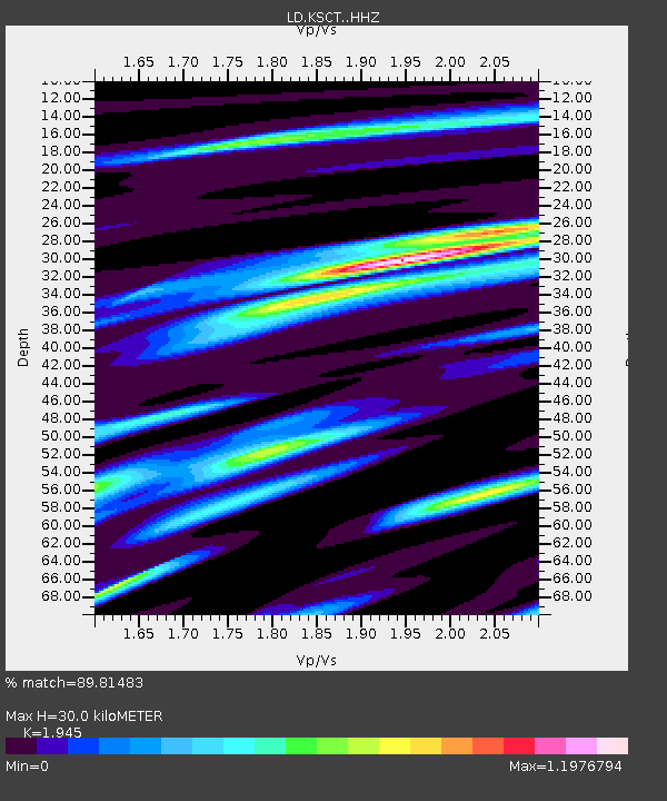
| Estimated Moho Depth: |
30.0 km |
| Estimated Crust Vp/Vs: |
1.95 |
| Assumed Crust Vp: |
6.472 km/s |
| Estimated Crust Vs: |
3.327 km/s |
| Estimated Crust Poisson's Ratio: |
0.32 |
|
| Radial Match: |
89.81483 % |
| Radial Bump: |
252 |
| Transverse Match: |
71.18848 % |
| Transverse Bump: |
400 |
| SOD ConfigId: |
30536071 |
| Insert Time: |
2023-07-28 09:52:36.387 +0000 |
| GWidth: |
2.5 |
| Max Bumps: |
400 |
| Tol: |
0.001 |
|

Signal To Noise
| Channel | StoN | STA | LTA |
| LD:KSCT: :HHZ:20230714T09:34:53.310012Z | 9.039456 | 1.5464173E-6 | 1.7107415E-7 |
| LD:KSCT: :HHN:20230714T09:34:53.310012Z | 8.459474 | 8.1236726E-7 | 9.6030476E-8 |
| LD:KSCT: :HHE:20230714T09:34:53.310012Z | 6.857834 | 5.8806495E-7 | 8.5750834E-8 |
| Arrivals |
| Ps | 4.7 SECOND |
| PpPs | 13 SECOND |
| PsPs/PpSs | 17 SECOND |


