You are here: Home > Network List > MB - Montana Regional Seismic Network Stations List
> Station GBMT Granite Butte > Earthquake Result Viewer
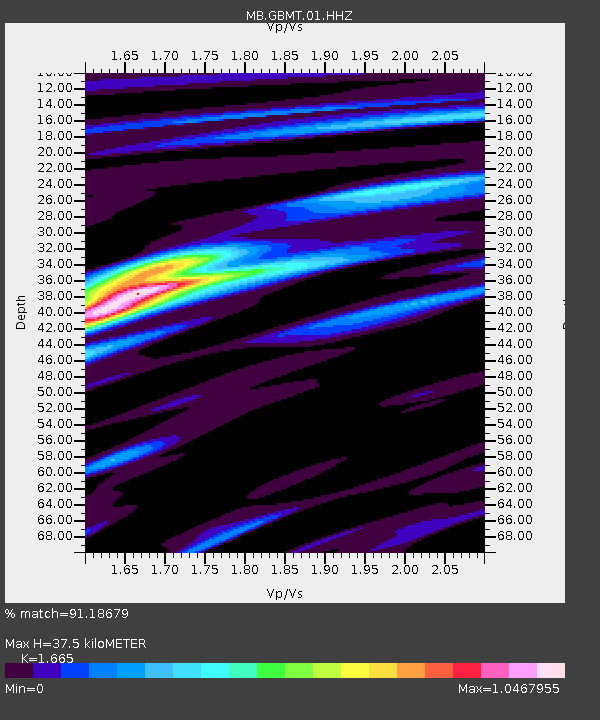
GBMT Granite Butte - Earthquake Result Viewer
| Earthquake location: |
Near Coast Of Chiapas, Mexico |
| Earthquake latitude/longitude: |
15.0/-93.9 |
| Earthquake time(UTC): |
2023/07/14 (195) 09:29:01 GMT |
| Earthquake Depth: |
35 km |
| Earthquake Magnitude: |
6.3 mww |
| Earthquake Catalog/Contributor: |
NEIC PDE/us |
|
| Network: |
MB Montana Regional Seismic Network |
| Station: |
GBMT Granite Butte |
| Lat/Lon: |
46.86 N/112.46 W |
| Elevation: |
2248 m |
|
| Distance: |
35.3 deg |
| Az: |
337.775 deg |
| Baz: |
147.822 deg |
| Ray Param: |
0.07722411 |
| Estimated Moho Depth: |
37.5 km |
| Estimated Crust Vp/Vs: |
1.66 |
| Assumed Crust Vp: |
6.353 km/s |
| Estimated Crust Vs: |
3.816 km/s |
| Estimated Crust Poisson's Ratio: |
0.22 |
|
| Radial Match: |
91.18679 % |
| Radial Bump: |
229 |
| Transverse Match: |
67.88435 % |
| Transverse Bump: |
400 |
| SOD ConfigId: |
30536071 |
| Insert Time: |
2023-07-28 09:52:58.324 +0000 |
| GWidth: |
2.5 |
| Max Bumps: |
400 |
| Tol: |
0.001 |
|

Signal To Noise
| Channel | StoN | STA | LTA |
| MB:GBMT:01:HHZ:20230714T09:35:22.800002Z | 54.365532 | 2.930088E-6 | 5.389606E-8 |
| MB:GBMT:01:HHN:20230714T09:35:22.800002Z | 37.28229 | 1.6539899E-6 | 4.4363954E-8 |
| MB:GBMT:01:HHE:20230714T09:35:22.800002Z | 13.110005 | 5.4133506E-7 | 4.129175E-8 |
| Arrivals |
| Ps | 4.2 SECOND |
| PpPs | 15 SECOND |
| PsPs/PpSs | 19 SECOND |


