You are here: Home > Network List > N4 - Central and EAstern US Network Stations List
> Station E62A Clayton Lake, ME, USA > Earthquake Result Viewer
E62A Clayton Lake, ME, USA - Earthquake Result Viewer
| Earthquake location: |
Near Coast Of Chiapas, Mexico |
| Earthquake latitude/longitude: |
15.0/-93.9 |
| Earthquake time(UTC): |
2023/07/14 (195) 09:29:01 GMT |
| Earthquake Depth: |
35 km |
| Earthquake Magnitude: |
6.3 mww |
| Earthquake Catalog/Contributor: |
NEIC PDE/us |
|
| Network: |
N4 Central and EAstern US Network |
| Station: |
E62A Clayton Lake, ME, USA |
| Lat/Lon: |
46.62 N/69.52 W |
| Elevation: |
356 m |
|
| Distance: |
37.5 deg |
| Az: |
27.841 deg |
| Baz: |
220.895 deg |
| Ray Param: |
0.07604232 |
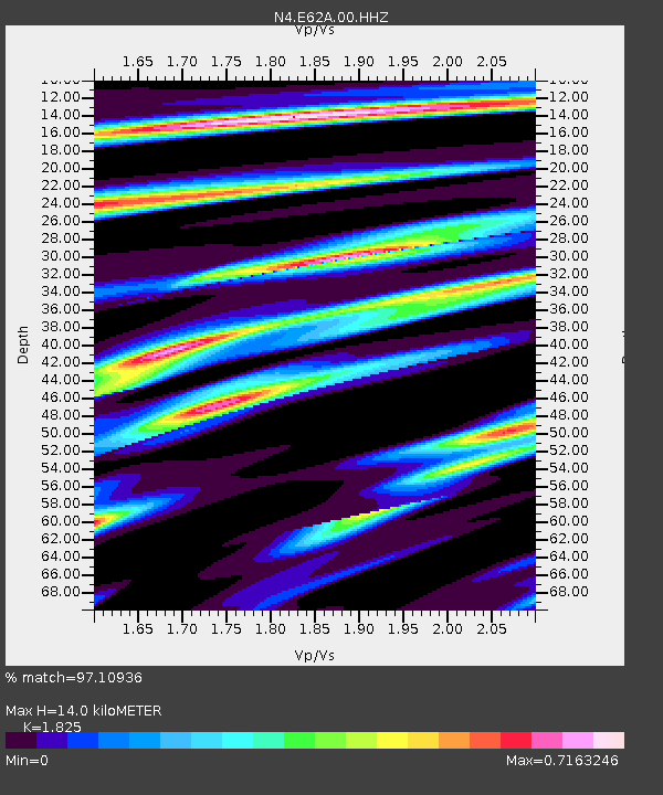
| Estimated Moho Depth: |
14.0 km |
| Estimated Crust Vp/Vs: |
1.83 |
| Assumed Crust Vp: |
6.419 km/s |
| Estimated Crust Vs: |
3.517 km/s |
| Estimated Crust Poisson's Ratio: |
0.29 |
|
| Radial Match: |
97.10936 % |
| Radial Bump: |
121 |
| Transverse Match: |
91.94218 % |
| Transverse Bump: |
385 |
| SOD ConfigId: |
30536071 |
| Insert Time: |
2023-07-28 09:53:22.635 +0000 |
| GWidth: |
2.5 |
| Max Bumps: |
400 |
| Tol: |
0.001 |
|

Signal To Noise
| Channel | StoN | STA | LTA |
| N4:E62A:00:HHZ:20230714T09:35:41.310012Z | 13.725372 | 1.6682458E-6 | 1.2154467E-7 |
| N4:E62A:00:HH1:20230714T09:35:41.310012Z | 9.23113 | 7.941249E-7 | 8.602684E-8 |
| N4:E62A:00:HH2:20230714T09:35:41.310012Z | 7.415316 | 6.1331735E-7 | 8.270953E-8 |
| Arrivals |
| Ps | 1.9 SECOND |
| PpPs | 5.7 SECOND |
| PsPs/PpSs | 7.7 SECOND |


