You are here: Home > Network List > UU - University of Utah Regional Network Stations List
> Station GAWY Genesis Alkali Granger, WY, USA > Earthquake Result Viewer
GAWY Genesis Alkali Granger, WY, USA - Earthquake Result Viewer
| Earthquake location: |
Caribbean Sea |
| Earthquake latitude/longitude: |
13.2/-81.2 |
| Earthquake time(UTC): |
2018/11/25 (329) 03:40:51 GMT |
| Earthquake Depth: |
10 km |
| Earthquake Magnitude: |
6.0 Mww |
| Earthquake Catalog/Contributor: |
NEIC PDE/us |
|
| Network: |
UU University of Utah Regional Network |
| Station: |
GAWY Genesis Alkali Granger, WY, USA |
| Lat/Lon: |
41.74 N/109.85 W |
| Elevation: |
2011 m |
|
| Distance: |
37.9 deg |
| Az: |
324.167 deg |
| Baz: |
130.361 deg |
| Ray Param: |
0.07589657 |
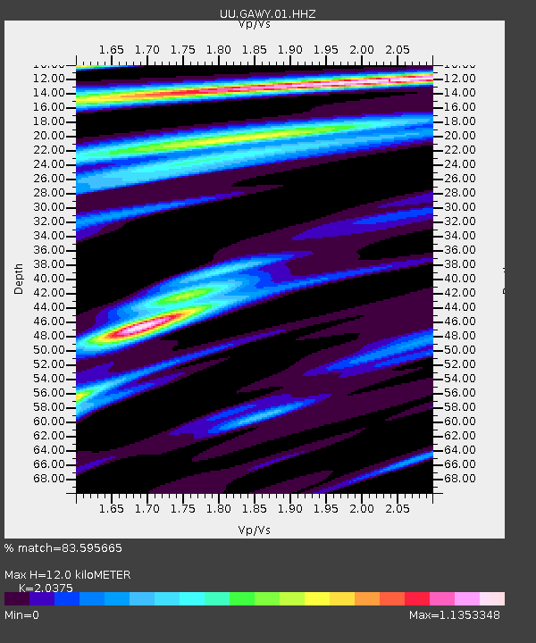
| Estimated Moho Depth: |
12.0 km |
| Estimated Crust Vp/Vs: |
2.04 |
| Assumed Crust Vp: |
6.207 km/s |
| Estimated Crust Vs: |
3.046 km/s |
| Estimated Crust Poisson's Ratio: |
0.34 |
|
| Radial Match: |
83.595665 % |
| Radial Bump: |
400 |
| Transverse Match: |
82.19174 % |
| Transverse Bump: |
286 |
| SOD ConfigId: |
3165032 |
| Insert Time: |
2018-12-09 03:50:51.312 +0000 |
| GWidth: |
2.5 |
| Max Bumps: |
400 |
| Tol: |
0.001 |
|

Signal To Noise
| Channel | StoN | STA | LTA |
| UU:GAWY:01:HHZ:20181125T03:47:37.079988Z | 1.1309783 | 2.4842555E-8 | 2.1965542E-8 |
| UU:GAWY:01:HHN:20181125T03:47:37.079988Z | 2.328319 | 3.693007E-8 | 1.5861259E-8 |
| UU:GAWY:01:HHE:20181125T03:47:37.079988Z | 0.78401625 | 1.3601336E-8 | 1.7348283E-8 |
| Arrivals |
| Ps | 2.1 SECOND |
| PpPs | 5.5 SECOND |
| PsPs/PpSs | 7.7 SECOND |


