You are here: Home > Network List > PQ - Public Safety Geoscience Program Canadian Research Network (PSGP) Stations List
> Station TSIIG Tsiigehtchic, Northwest Territory > Earthquake Result Viewer
TSIIG Tsiigehtchic, Northwest Territory - Earthquake Result Viewer
| Earthquake location: |
Near Coast Of Chiapas, Mexico |
| Earthquake latitude/longitude: |
15.0/-93.9 |
| Earthquake time(UTC): |
2023/07/14 (195) 09:29:01 GMT |
| Earthquake Depth: |
35 km |
| Earthquake Magnitude: |
6.3 mww |
| Earthquake Catalog/Contributor: |
NEIC PDE/us |
|
| Network: |
PQ Public Safety Geoscience Program Canadian Research Network (PSGP) |
| Station: |
TSIIG Tsiigehtchic, Northwest Territory |
| Lat/Lon: |
67.44 N/133.74 W |
| Elevation: |
56 m |
|
| Distance: |
58.4 deg |
| Az: |
343.121 deg |
| Baz: |
133.355 deg |
| Ray Param: |
0.062795915 |
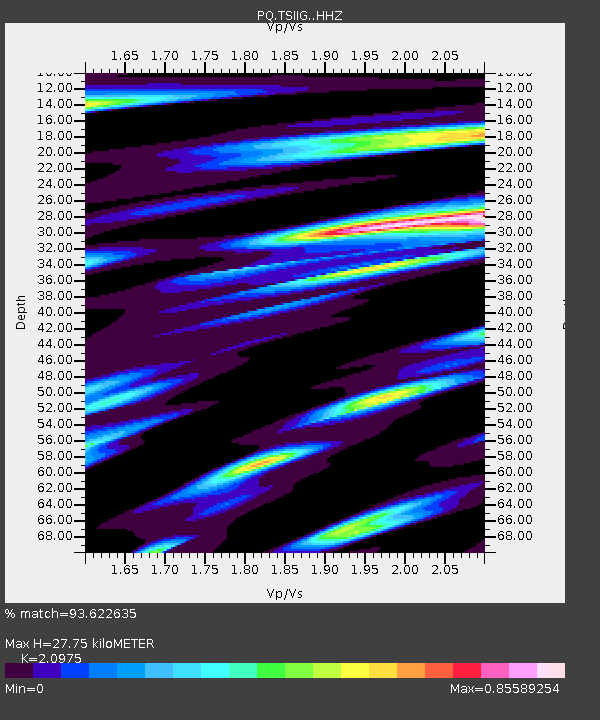
| Estimated Moho Depth: |
27.75 km |
| Estimated Crust Vp/Vs: |
2.10 |
| Assumed Crust Vp: |
6.171 km/s |
| Estimated Crust Vs: |
2.942 km/s |
| Estimated Crust Poisson's Ratio: |
0.35 |
|
| Radial Match: |
93.622635 % |
| Radial Bump: |
399 |
| Transverse Match: |
81.4974 % |
| Transverse Bump: |
400 |
| SOD ConfigId: |
30536071 |
| Insert Time: |
2023-07-28 09:56:26.946 +0000 |
| GWidth: |
2.5 |
| Max Bumps: |
400 |
| Tol: |
0.001 |
|

Signal To Noise
| Channel | StoN | STA | LTA |
| PQ:TSIIG: :HHZ:20230714T09:38:22.690017Z | 57.76963 | 3.456803E-6 | 5.983772E-8 |
| PQ:TSIIG: :HHN:20230714T09:38:22.690017Z | 20.861124 | 1.1980978E-6 | 5.7432082E-8 |
| PQ:TSIIG: :HHE:20230714T09:38:22.690017Z | 26.061043 | 1.2849684E-6 | 4.9306106E-8 |
| Arrivals |
| Ps | 5.1 SECOND |
| PpPs | 13 SECOND |
| PsPs/PpSs | 19 SECOND |


