You are here: Home > Network List > UO - University of Oregon Regional Network Stations List
> Station LAIR Myrtle Point, OR, USA > Earthquake Result Viewer
LAIR Myrtle Point, OR, USA - Earthquake Result Viewer
| Earthquake location: |
Near Coast Of Chiapas, Mexico |
| Earthquake latitude/longitude: |
15.0/-93.9 |
| Earthquake time(UTC): |
2023/07/14 (195) 09:29:01 GMT |
| Earthquake Depth: |
35 km |
| Earthquake Magnitude: |
6.3 mww |
| Earthquake Catalog/Contributor: |
NEIC PDE/us |
|
| Network: |
UO University of Oregon Regional Network |
| Station: |
LAIR Myrtle Point, OR, USA |
| Lat/Lon: |
43.16 N/123.93 W |
| Elevation: |
128 m |
|
| Distance: |
38.0 deg |
| Az: |
323.505 deg |
| Baz: |
128.246 deg |
| Ray Param: |
0.07573979 |
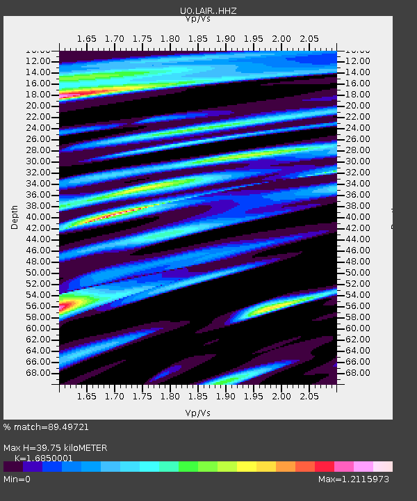
| Estimated Moho Depth: |
39.75 km |
| Estimated Crust Vp/Vs: |
1.69 |
| Assumed Crust Vp: |
6.522 km/s |
| Estimated Crust Vs: |
3.87 km/s |
| Estimated Crust Poisson's Ratio: |
0.23 |
|
| Radial Match: |
89.49721 % |
| Radial Bump: |
400 |
| Transverse Match: |
80.7116 % |
| Transverse Bump: |
400 |
| SOD ConfigId: |
30536071 |
| Insert Time: |
2023-07-28 09:58:27.214 +0000 |
| GWidth: |
2.5 |
| Max Bumps: |
400 |
| Tol: |
0.001 |
|

Signal To Noise
| Channel | StoN | STA | LTA |
| UO:LAIR: :HHZ:20230714T09:35:45.908004Z | 38.507412 | 3.9104884E-6 | 1.0155157E-7 |
| UO:LAIR: :HHN:20230714T09:35:45.908004Z | 4.731201 | 7.1585777E-7 | 1.5130573E-7 |
| UO:LAIR: :HHE:20230714T09:35:45.908004Z | 11.273852 | 1.0841172E-6 | 9.61621E-8 |
| Arrivals |
| Ps | 4.5 SECOND |
| PpPs | 15 SECOND |
| PsPs/PpSs | 20 SECOND |


