You are here: Home > Network List > UO - University of Oregon Regional Network Stations List
> Station NECAN Necanicum, OR, USA > Earthquake Result Viewer
NECAN Necanicum, OR, USA - Earthquake Result Viewer
| Earthquake location: |
Near Coast Of Chiapas, Mexico |
| Earthquake latitude/longitude: |
15.0/-93.9 |
| Earthquake time(UTC): |
2023/07/14 (195) 09:29:01 GMT |
| Earthquake Depth: |
35 km |
| Earthquake Magnitude: |
6.3 mww |
| Earthquake Catalog/Contributor: |
NEIC PDE/us |
|
| Network: |
UO University of Oregon Regional Network |
| Station: |
NECAN Necanicum, OR, USA |
| Lat/Lon: |
45.87 N/123.82 W |
| Elevation: |
517 m |
|
| Distance: |
39.7 deg |
| Az: |
326.902 deg |
| Baz: |
130.967 deg |
| Ray Param: |
0.07476171 |
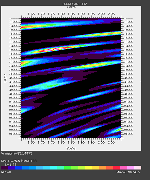
| Estimated Moho Depth: |
25.5 km |
| Estimated Crust Vp/Vs: |
1.76 |
| Assumed Crust Vp: |
6.566 km/s |
| Estimated Crust Vs: |
3.731 km/s |
| Estimated Crust Poisson's Ratio: |
0.26 |
|
| Radial Match: |
85.14975 % |
| Radial Bump: |
400 |
| Transverse Match: |
73.70405 % |
| Transverse Bump: |
400 |
| SOD ConfigId: |
30536071 |
| Insert Time: |
2023-07-28 09:58:41.106 +0000 |
| GWidth: |
2.5 |
| Max Bumps: |
400 |
| Tol: |
0.001 |
|

Signal To Noise
| Channel | StoN | STA | LTA |
| UO:NECAN: :HHZ:20230714T09:35:59.830001Z | 23.85748 | 2.9323483E-6 | 1.2291106E-7 |
| UO:NECAN: :HHN:20230714T09:35:59.830001Z | 6.005978 | 1.0366366E-6 | 1.7260079E-7 |
| UO:NECAN: :HHE:20230714T09:35:59.830001Z | 6.9266524 | 1.18479E-6 | 1.71048E-7 |
| Arrivals |
| Ps | 3.2 SECOND |
| PpPs | 9.9 SECOND |
| PsPs/PpSs | 13 SECOND |


