You are here: Home > Network List > UO - University of Oregon Regional Network Stations List
> Station TDWTR Tidewater, OR, USA > Earthquake Result Viewer
TDWTR Tidewater, OR, USA - Earthquake Result Viewer
| Earthquake location: |
Near Coast Of Chiapas, Mexico |
| Earthquake latitude/longitude: |
15.0/-93.9 |
| Earthquake time(UTC): |
2023/07/14 (195) 09:29:01 GMT |
| Earthquake Depth: |
35 km |
| Earthquake Magnitude: |
6.3 mww |
| Earthquake Catalog/Contributor: |
NEIC PDE/us |
|
| Network: |
UO University of Oregon Regional Network |
| Station: |
TDWTR Tidewater, OR, USA |
| Lat/Lon: |
44.35 N/123.89 W |
| Elevation: |
594 m |
|
| Distance: |
38.8 deg |
| Az: |
325.026 deg |
| Baz: |
129.469 deg |
| Ray Param: |
0.07533653 |
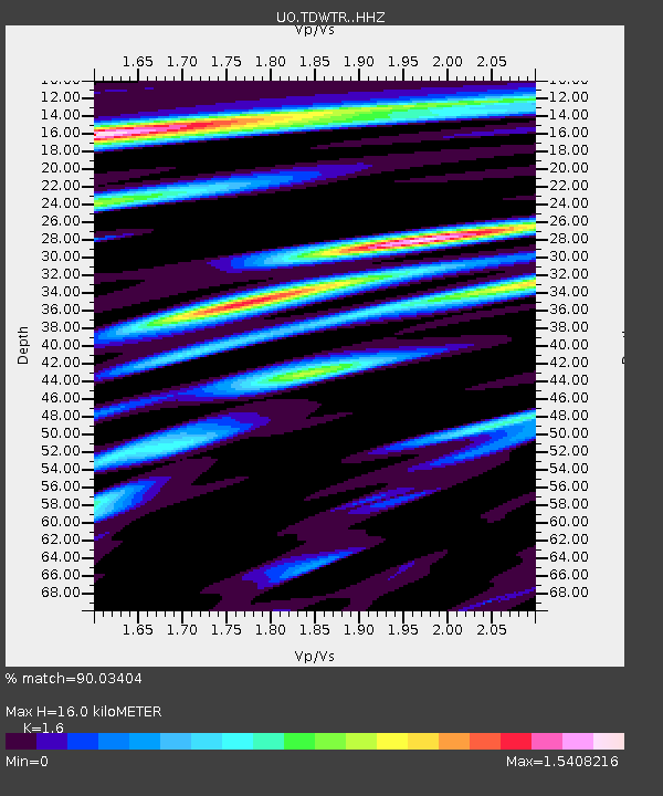
| Estimated Moho Depth: |
16.0 km |
| Estimated Crust Vp/Vs: |
1.60 |
| Assumed Crust Vp: |
6.566 km/s |
| Estimated Crust Vs: |
4.104 km/s |
| Estimated Crust Poisson's Ratio: |
0.18 |
|
| Radial Match: |
90.03404 % |
| Radial Bump: |
400 |
| Transverse Match: |
88.44519 % |
| Transverse Bump: |
400 |
| SOD ConfigId: |
30536071 |
| Insert Time: |
2023-07-28 09:59:04.960 +0000 |
| GWidth: |
2.5 |
| Max Bumps: |
400 |
| Tol: |
0.001 |
|

Signal To Noise
| Channel | StoN | STA | LTA |
| UO:TDWTR: :HHZ:20230714T09:35:51.949996Z | 29.171495 | 4.9979367E-6 | 1.7132948E-7 |
| UO:TDWTR: :HHN:20230714T09:35:51.949996Z | 6.4370832 | 1.5697126E-6 | 2.4385463E-7 |
| UO:TDWTR: :HHE:20230714T09:35:51.949996Z | 4.643108 | 1.143309E-6 | 2.4623787E-7 |
| Arrivals |
| Ps | 1.6 SECOND |
| PpPs | 5.8 SECOND |
| PsPs/PpSs | 7.4 SECOND |


