You are here: Home > Network List > US - United States National Seismic Network Stations List
> Station PKME Peaks-Kenny State Park, Maine, USA > Earthquake Result Viewer
PKME Peaks-Kenny State Park, Maine, USA - Earthquake Result Viewer
| Earthquake location: |
Near Coast Of Chiapas, Mexico |
| Earthquake latitude/longitude: |
15.0/-93.9 |
| Earthquake time(UTC): |
2023/07/14 (195) 09:29:01 GMT |
| Earthquake Depth: |
35 km |
| Earthquake Magnitude: |
6.3 mww |
| Earthquake Catalog/Contributor: |
NEIC PDE/us |
|
| Network: |
US United States National Seismic Network |
| Station: |
PKME Peaks-Kenny State Park, Maine, USA |
| Lat/Lon: |
45.26 N/69.29 W |
| Elevation: |
108 m |
|
| Distance: |
36.6 deg |
| Az: |
29.538 deg |
| Baz: |
222.414 deg |
| Ray Param: |
0.07656427 |
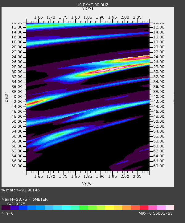
| Estimated Moho Depth: |
28.75 km |
| Estimated Crust Vp/Vs: |
1.94 |
| Assumed Crust Vp: |
6.419 km/s |
| Estimated Crust Vs: |
3.313 km/s |
| Estimated Crust Poisson's Ratio: |
0.32 |
|
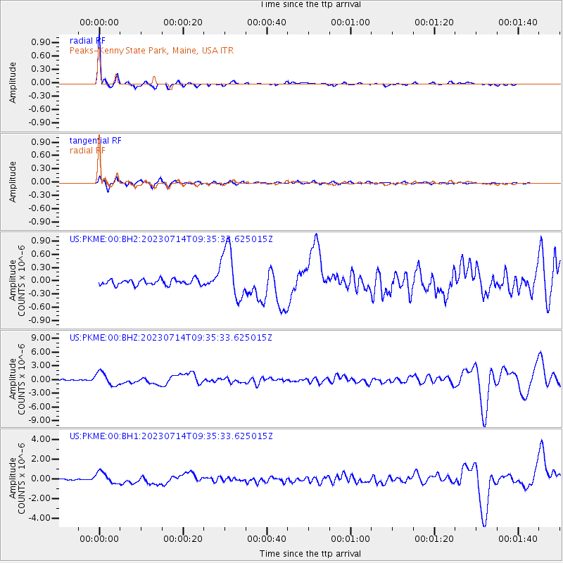
| Radial Match: |
93.98146 % |
| Radial Bump: |
258 |
| Transverse Match: |
83.83644 % |
| Transverse Bump: |
396 |
| SOD ConfigId: |
30536071 |
| Insert Time: |
2023-07-28 10:00:10.148 +0000 |
| GWidth: |
2.5 |
| Max Bumps: |
400 |
| Tol: |
0.001 |
|
Signal To Noise
| Channel | StoN | STA | LTA |
| US:PKME:00:BHZ:20230714T09:35:33.625015Z | 11.674061 | 1.4270657E-6 | 1.2224245E-7 |
| US:PKME:00:BH1:20230714T09:35:33.625015Z | 6.4349623 | 5.7408545E-7 | 8.921349E-8 |
| US:PKME:00:BH2:20230714T09:35:33.625015Z | 9.319417 | 6.0314375E-7 | 6.471904E-8 |
| Arrivals |
| Ps | 4.5 SECOND |
| PpPs | 12 SECOND |
| PsPs/PpSs | 17 SECOND |


