You are here: Home > Network List > UW - Pacific Northwest Regional Seismic Network Stations List
> Station BDGR Fisse-Smith Property, Kittitas, WA, USA > Earthquake Result Viewer
BDGR Fisse-Smith Property, Kittitas, WA, USA - Earthquake Result Viewer
| Earthquake location: |
Near Coast Of Chiapas, Mexico |
| Earthquake latitude/longitude: |
15.0/-93.9 |
| Earthquake time(UTC): |
2023/07/14 (195) 09:29:01 GMT |
| Earthquake Depth: |
35 km |
| Earthquake Magnitude: |
6.3 mww |
| Earthquake Catalog/Contributor: |
NEIC PDE/us |
|
| Network: |
UW Pacific Northwest Regional Seismic Network |
| Station: |
BDGR Fisse-Smith Property, Kittitas, WA, USA |
| Lat/Lon: |
46.86 N/120.30 W |
| Elevation: |
642 m |
|
| Distance: |
38.6 deg |
| Az: |
330.71 deg |
| Baz: |
136.465 deg |
| Ray Param: |
0.075415365 |
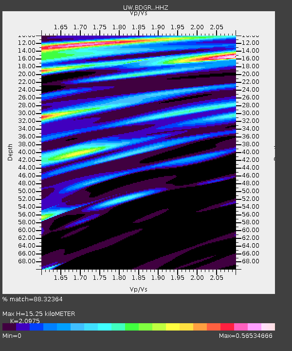
| Estimated Moho Depth: |
15.25 km |
| Estimated Crust Vp/Vs: |
2.10 |
| Assumed Crust Vp: |
6.597 km/s |
| Estimated Crust Vs: |
3.145 km/s |
| Estimated Crust Poisson's Ratio: |
0.35 |
|
| Radial Match: |
88.32364 % |
| Radial Bump: |
391 |
| Transverse Match: |
81.25672 % |
| Transverse Bump: |
400 |
| SOD ConfigId: |
30536071 |
| Insert Time: |
2023-07-28 10:00:37.465 +0000 |
| GWidth: |
2.5 |
| Max Bumps: |
400 |
| Tol: |
0.001 |
|

Signal To Noise
| Channel | StoN | STA | LTA |
| UW:BDGR: :HHZ:20230714T09:35:50.819991Z | 57.097446 | 2.9360401E-6 | 5.1421566E-8 |
| UW:BDGR: :HHN:20230714T09:35:50.819991Z | 14.154206 | 7.355508E-7 | 5.196694E-8 |
| UW:BDGR: :HHE:20230714T09:35:50.819991Z | 21.519384 | 1.037548E-6 | 4.8214577E-8 |
| Arrivals |
| Ps | 2.7 SECOND |
| PpPs | 6.7 SECOND |
| PsPs/PpSs | 9.4 SECOND |


