You are here: Home > Network List > UW - Pacific Northwest Regional Seismic Network Stations List
> Station DAVN Davenport, WA, USA > Earthquake Result Viewer
DAVN Davenport, WA, USA - Earthquake Result Viewer
| Earthquake location: |
Near Coast Of Chiapas, Mexico |
| Earthquake latitude/longitude: |
15.0/-93.9 |
| Earthquake time(UTC): |
2023/07/14 (195) 09:29:01 GMT |
| Earthquake Depth: |
35 km |
| Earthquake Magnitude: |
6.3 mww |
| Earthquake Catalog/Contributor: |
NEIC PDE/us |
|
| Network: |
UW Pacific Northwest Regional Seismic Network |
| Station: |
DAVN Davenport, WA, USA |
| Lat/Lon: |
47.80 N/118.27 W |
| Elevation: |
483 m |
|
| Distance: |
38.4 deg |
| Az: |
333.368 deg |
| Baz: |
140.028 deg |
| Ray Param: |
0.07553794 |
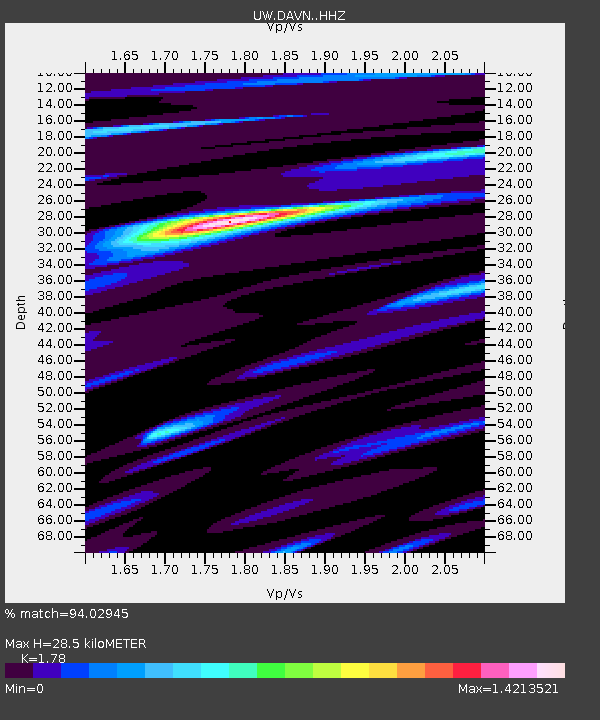
| Estimated Moho Depth: |
28.5 km |
| Estimated Crust Vp/Vs: |
1.78 |
| Assumed Crust Vp: |
6.419 km/s |
| Estimated Crust Vs: |
3.606 km/s |
| Estimated Crust Poisson's Ratio: |
0.27 |
|
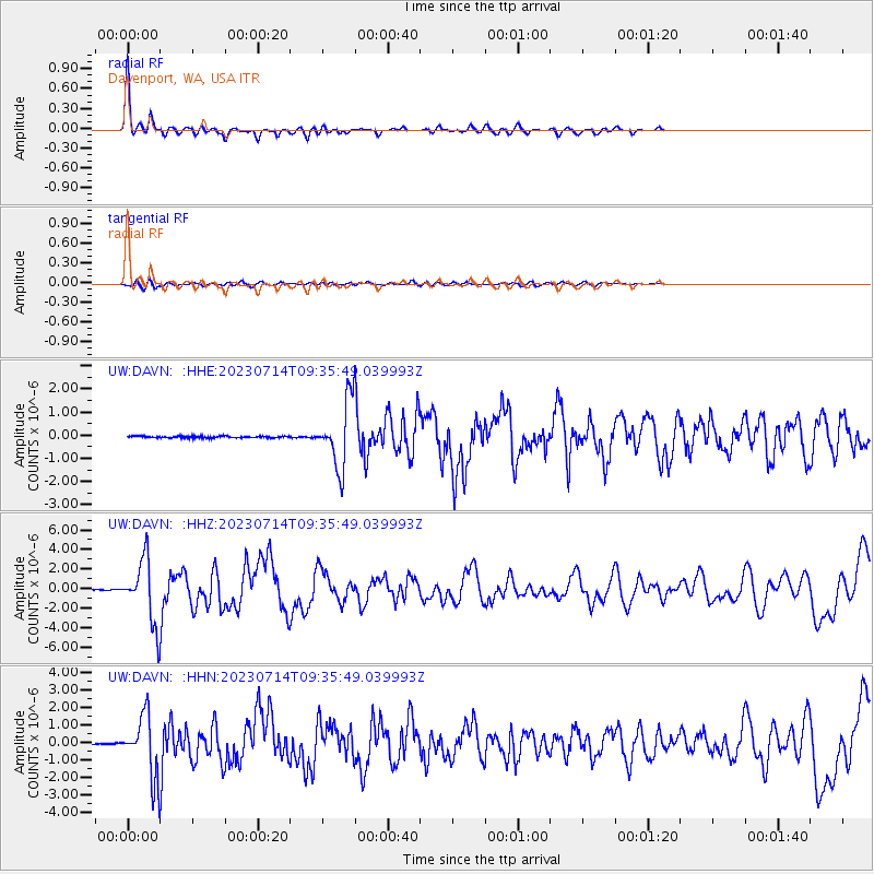
| Radial Match: |
94.02945 % |
| Radial Bump: |
299 |
| Transverse Match: |
60.71604 % |
| Transverse Bump: |
400 |
| SOD ConfigId: |
30536071 |
| Insert Time: |
2023-07-28 10:01:13.641 +0000 |
| GWidth: |
2.5 |
| Max Bumps: |
400 |
| Tol: |
0.001 |
|
Signal To Noise
| Channel | StoN | STA | LTA |
| UW:DAVN: :HHZ:20230714T09:35:49.039993Z | 61.78632 | 3.1479658E-6 | 5.0949236E-8 |
| UW:DAVN: :HHN:20230714T09:35:49.039993Z | 40.367184 | 1.6644127E-6 | 4.1231825E-8 |
| UW:DAVN: :HHE:20230714T09:35:49.039993Z | 38.107986 | 1.4006877E-6 | 3.675575E-8 |
| Arrivals |
| Ps | 3.7 SECOND |
| PpPs | 11 SECOND |
| PsPs/PpSs | 15 SECOND |


