You are here: Home > Network List > UW - Pacific Northwest Regional Seismic Network Stations List
> Station IZEE Izee, OR, USA > Earthquake Result Viewer
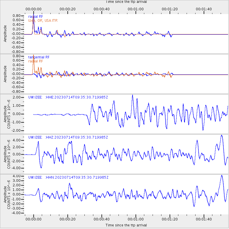
IZEE Izee, OR, USA - Earthquake Result Viewer

| Earthquake location: |
Near Coast Of Chiapas, Mexico |
| Earthquake latitude/longitude: |
15.0/-93.9 |
| Earthquake time(UTC): |
2023/07/14 (195) 09:29:01 GMT |
| Earthquake Depth: |
35 km |
| Earthquake Magnitude: |
6.3 mww |
| Earthquake Catalog/Contributor: |
NEIC PDE/us |
|
| Network: |
UW Pacific Northwest Regional Seismic Network |
| Station: |
IZEE Izee, OR, USA |
| Lat/Lon: |
44.08 N/119.50 W |
| Elevation: |
1299 m |
|
| Distance: |
36.2 deg |
| Az: |
328.181 deg |
| Baz: |
135.02 deg |
| Ray Param: |
0.07675088 |
| Estimated Moho Depth: |
29.0 km |
| Estimated Crust Vp/Vs: |
1.93 |
| Assumed Crust Vp: |
6.571 km/s |
| Estimated Crust Vs: |
3.405 km/s |
| Estimated Crust Poisson's Ratio: |
0.32 |
|
| Radial Match: |
88.924286 % |
| Radial Bump: |
241 |
| Transverse Match: |
70.36395 % |
| Transverse Bump: |
400 |
| SOD ConfigId: |
30536071 |
| Insert Time: |
2023-07-28 10:02:03.809 +0000 |
| GWidth: |
2.5 |
| Max Bumps: |
400 |
| Tol: |
0.001 |
|
Signal To Noise
| Channel | StoN | STA | LTA |
| UW:IZEE: :HHZ:20230714T09:35:30.719985Z | 37.61081 | 2.0662892E-6 | 5.493871E-8 |
| UW:IZEE: :HHN:20230714T09:35:30.719985Z | 13.580291 | 7.694256E-7 | 5.6657516E-8 |
| UW:IZEE: :HHE:20230714T09:35:30.719985Z | 13.9643755 | 6.284079E-7 | 4.5000792E-8 |
| Arrivals |
| Ps | 4.4 SECOND |
| PpPs | 12 SECOND |
| PsPs/PpSs | 16 SECOND |


