You are here: Home > Network List > UW - Pacific Northwest Regional Seismic Network Stations List
> Station LOPEZ Johns Point, Lopez Island, WA, USA > Earthquake Result Viewer
LOPEZ Johns Point, Lopez Island, WA, USA - Earthquake Result Viewer
| Earthquake location: |
Near Coast Of Chiapas, Mexico |
| Earthquake latitude/longitude: |
15.0/-93.9 |
| Earthquake time(UTC): |
2023/07/14 (195) 09:29:01 GMT |
| Earthquake Depth: |
35 km |
| Earthquake Magnitude: |
6.3 mww |
| Earthquake Catalog/Contributor: |
NEIC PDE/us |
|
| Network: |
UW Pacific Northwest Regional Seismic Network |
| Station: |
LOPEZ Johns Point, Lopez Island, WA, USA |
| Lat/Lon: |
48.44 N/122.89 W |
| Elevation: |
10 m |
|
| Distance: |
41.0 deg |
| Az: |
330.494 deg |
| Baz: |
134.39 deg |
| Ray Param: |
0.074009255 |
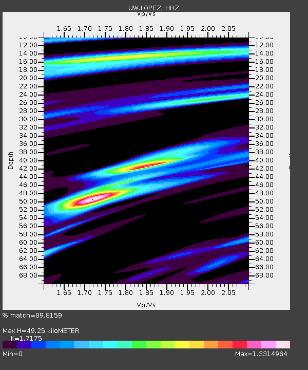
| Estimated Moho Depth: |
49.25 km |
| Estimated Crust Vp/Vs: |
1.72 |
| Assumed Crust Vp: |
6.566 km/s |
| Estimated Crust Vs: |
3.823 km/s |
| Estimated Crust Poisson's Ratio: |
0.24 |
|
| Radial Match: |
89.8159 % |
| Radial Bump: |
400 |
| Transverse Match: |
77.07962 % |
| Transverse Bump: |
400 |
| SOD ConfigId: |
30536071 |
| Insert Time: |
2023-07-28 10:02:31.647 +0000 |
| GWidth: |
2.5 |
| Max Bumps: |
400 |
| Tol: |
0.001 |
|

Signal To Noise
| Channel | StoN | STA | LTA |
| UW:LOPEZ: :HHZ:20230714T09:36:10.34999Z | 24.630108 | 3.0034453E-6 | 1.2194202E-7 |
| UW:LOPEZ: :HHN:20230714T09:36:10.34999Z | 11.483766 | 1.284131E-6 | 1.1182143E-7 |
| UW:LOPEZ: :HHE:20230714T09:36:10.34999Z | 12.737335 | 1.2525668E-6 | 9.833821E-8 |
| Arrivals |
| Ps | 5.8 SECOND |
| PpPs | 19 SECOND |
| PsPs/PpSs | 25 SECOND |


