You are here: Home > Network List > UW - Pacific Northwest Regional Seismic Network Stations List
> Station LUMI Lummi Island, WA > Earthquake Result Viewer
LUMI Lummi Island, WA - Earthquake Result Viewer
| Earthquake location: |
Near Coast Of Chiapas, Mexico |
| Earthquake latitude/longitude: |
15.0/-93.9 |
| Earthquake time(UTC): |
2023/07/14 (195) 09:29:01 GMT |
| Earthquake Depth: |
35 km |
| Earthquake Magnitude: |
6.3 mww |
| Earthquake Catalog/Contributor: |
NEIC PDE/us |
|
| Network: |
UW Pacific Northwest Regional Seismic Network |
| Station: |
LUMI Lummi Island, WA |
| Lat/Lon: |
48.72 N/122.71 W |
| Elevation: |
19 m |
|
| Distance: |
41.1 deg |
| Az: |
330.93 deg |
| Baz: |
134.854 deg |
| Ray Param: |
0.07393926 |
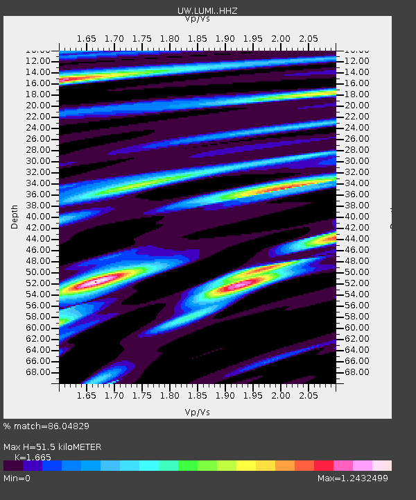
| Estimated Moho Depth: |
51.5 km |
| Estimated Crust Vp/Vs: |
1.66 |
| Assumed Crust Vp: |
6.566 km/s |
| Estimated Crust Vs: |
3.944 km/s |
| Estimated Crust Poisson's Ratio: |
0.22 |
|
| Radial Match: |
86.04829 % |
| Radial Bump: |
378 |
| Transverse Match: |
79.47854 % |
| Transverse Bump: |
400 |
| SOD ConfigId: |
30536071 |
| Insert Time: |
2023-07-28 10:02:36.277 +0000 |
| GWidth: |
2.5 |
| Max Bumps: |
400 |
| Tol: |
0.001 |
|

Signal To Noise
| Channel | StoN | STA | LTA |
| UW:LUMI: :HHZ:20230714T09:36:11.280013Z | 40.514687 | 3.337295E-6 | 8.237247E-8 |
| UW:LUMI: :HHN:20230714T09:36:11.280013Z | 10.637306 | 1.3129818E-6 | 1.2343179E-7 |
| UW:LUMI: :HHE:20230714T09:36:11.280013Z | 11.965426 | 1.5045187E-6 | 1.2573882E-7 |
| Arrivals |
| Ps | 5.6 SECOND |
| PpPs | 19 SECOND |
| PsPs/PpSs | 25 SECOND |


