You are here: Home > Network List > UW - Pacific Northwest Regional Seismic Network Stations List
> Station RPW2 RPW2, Rockport WA > Earthquake Result Viewer
RPW2 RPW2, Rockport WA - Earthquake Result Viewer
| Earthquake location: |
Near Coast Of Chiapas, Mexico |
| Earthquake latitude/longitude: |
15.0/-93.9 |
| Earthquake time(UTC): |
2023/07/14 (195) 09:29:01 GMT |
| Earthquake Depth: |
35 km |
| Earthquake Magnitude: |
6.3 mww |
| Earthquake Catalog/Contributor: |
NEIC PDE/us |
|
| Network: |
UW Pacific Northwest Regional Seismic Network |
| Station: |
RPW2 RPW2, Rockport WA |
| Lat/Lon: |
48.44 N/121.53 W |
| Elevation: |
694 m |
|
| Distance: |
40.3 deg |
| Az: |
331.491 deg |
| Baz: |
136.161 deg |
| Ray Param: |
0.07438963 |
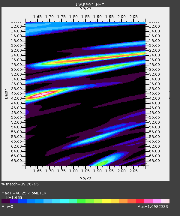
| Estimated Moho Depth: |
40.25 km |
| Estimated Crust Vp/Vs: |
1.66 |
| Assumed Crust Vp: |
6.566 km/s |
| Estimated Crust Vs: |
3.944 km/s |
| Estimated Crust Poisson's Ratio: |
0.22 |
|
| Radial Match: |
89.76795 % |
| Radial Bump: |
359 |
| Transverse Match: |
70.015335 % |
| Transverse Bump: |
400 |
| SOD ConfigId: |
30536071 |
| Insert Time: |
2023-07-28 10:03:27.746 +0000 |
| GWidth: |
2.5 |
| Max Bumps: |
400 |
| Tol: |
0.001 |
|

Signal To Noise
| Channel | StoN | STA | LTA |
| UW:RPW2: :HHZ:20230714T09:36:05.150009Z | 48.309887 | 2.2154102E-6 | 4.5858314E-8 |
| UW:RPW2: :HHN:20230714T09:36:05.150009Z | 20.054005 | 1.1340435E-6 | 5.6549478E-8 |
| UW:RPW2: :HHE:20230714T09:36:05.150009Z | 17.447506 | 6.420781E-7 | 3.6800564E-8 |
| Arrivals |
| Ps | 4.4 SECOND |
| PpPs | 15 SECOND |
| PsPs/PpSs | 20 SECOND |


