You are here: Home > Network List > UW - Pacific Northwest Regional Seismic Network Stations List
> Station SAW St. Andrews, WA, USA > Earthquake Result Viewer
SAW St. Andrews, WA, USA - Earthquake Result Viewer
| Earthquake location: |
Near Coast Of Chiapas, Mexico |
| Earthquake latitude/longitude: |
15.0/-93.9 |
| Earthquake time(UTC): |
2023/07/14 (195) 09:29:01 GMT |
| Earthquake Depth: |
35 km |
| Earthquake Magnitude: |
6.3 mww |
| Earthquake Catalog/Contributor: |
NEIC PDE/us |
|
| Network: |
UW Pacific Northwest Regional Seismic Network |
| Station: |
SAW St. Andrews, WA, USA |
| Lat/Lon: |
47.70 N/119.40 W |
| Elevation: |
701 m |
|
| Distance: |
38.8 deg |
| Az: |
332.342 deg |
| Baz: |
138.394 deg |
| Ray Param: |
0.07529208 |
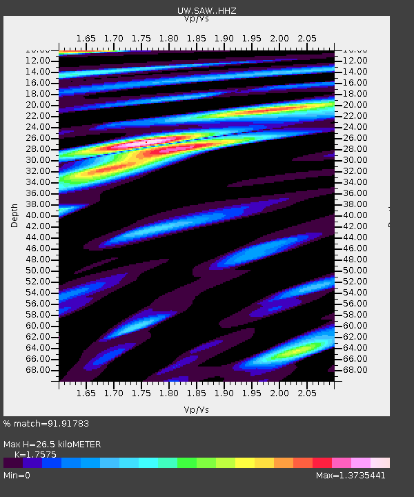
| Estimated Moho Depth: |
26.5 km |
| Estimated Crust Vp/Vs: |
1.76 |
| Assumed Crust Vp: |
6.419 km/s |
| Estimated Crust Vs: |
3.652 km/s |
| Estimated Crust Poisson's Ratio: |
0.26 |
|
| Radial Match: |
91.91783 % |
| Radial Bump: |
341 |
| Transverse Match: |
73.13648 % |
| Transverse Bump: |
400 |
| SOD ConfigId: |
30536071 |
| Insert Time: |
2023-07-28 10:03:32.052 +0000 |
| GWidth: |
2.5 |
| Max Bumps: |
400 |
| Tol: |
0.001 |
|

Signal To Noise
| Channel | StoN | STA | LTA |
| UW:SAW: :HHZ:20230714T09:35:52.569991Z | 97.51007 | 3.779147E-6 | 3.8756475E-8 |
| UW:SAW: :HHN:20230714T09:35:52.569991Z | 39.87593 | 1.6698433E-6 | 4.1875968E-8 |
| UW:SAW: :HHE:20230714T09:35:52.569991Z | 50.927036 | 1.5375363E-6 | 3.019096E-8 |
| Arrivals |
| Ps | 3.4 SECOND |
| PpPs | 11 SECOND |
| PsPs/PpSs | 14 SECOND |


