You are here: Home > Network List > UW - Pacific Northwest Regional Seismic Network Stations List
> Station YACT Yacolt, WA, USA > Earthquake Result Viewer
YACT Yacolt, WA, USA - Earthquake Result Viewer
| Earthquake location: |
Near Coast Of Chiapas, Mexico |
| Earthquake latitude/longitude: |
15.0/-93.9 |
| Earthquake time(UTC): |
2023/07/14 (195) 09:29:01 GMT |
| Earthquake Depth: |
35 km |
| Earthquake Magnitude: |
6.3 mww |
| Earthquake Catalog/Contributor: |
NEIC PDE/us |
|
| Network: |
UW Pacific Northwest Regional Seismic Network |
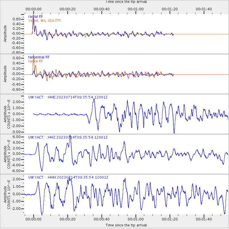
| Station: |
YACT Yacolt, WA, USA |
| Lat/Lon: |
45.93 N/122.42 W |
| Elevation: |
214 m |
|
| Distance: |
39.0 deg |
| Az: |
328.014 deg |
| Baz: |
132.832 deg |
| Ray Param: |
0.07518075 |
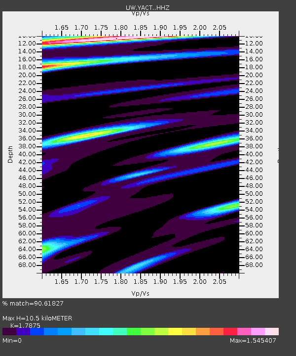
| Estimated Moho Depth: |
10.5 km |
| Estimated Crust Vp/Vs: |
1.79 |
| Assumed Crust Vp: |
6.566 km/s |
| Estimated Crust Vs: |
3.673 km/s |
| Estimated Crust Poisson's Ratio: |
0.27 |
|
| Radial Match: |
90.61827 % |
| Radial Bump: |
400 |
| Transverse Match: |
72.52268 % |
| Transverse Bump: |
400 |
| SOD ConfigId: |
30536071 |
| Insert Time: |
2023-07-28 10:04:33.380 +0000 |
| GWidth: |
2.5 |
| Max Bumps: |
400 |
| Tol: |
0.001 |
|
Signal To Noise
| Channel | StoN | STA | LTA |
| UW:YACT: :HHZ:20230714T09:35:54.12001Z | 37.305183 | 2.5138786E-6 | 6.738684E-8 |
| UW:YACT: :HHN:20230714T09:35:54.12001Z | 23.145353 | 1.0531461E-6 | 4.5501405E-8 |
| UW:YACT: :HHE:20230714T09:35:54.12001Z | 9.569757 | 7.145635E-7 | 7.4668925E-8 |
| Arrivals |
| Ps | 1.4 SECOND |
| PpPs | 4.1 SECOND |
| PsPs/PpSs | 5.5 SECOND |


