You are here: Home > Network List > WI - West Indies IPGP Network Stations List
> Station MAGL Barre de l'ile, Marie-Galante, Guadeloupe > Earthquake Result Viewer
MAGL Barre de l'ile, Marie-Galante, Guadeloupe - Earthquake Result Viewer
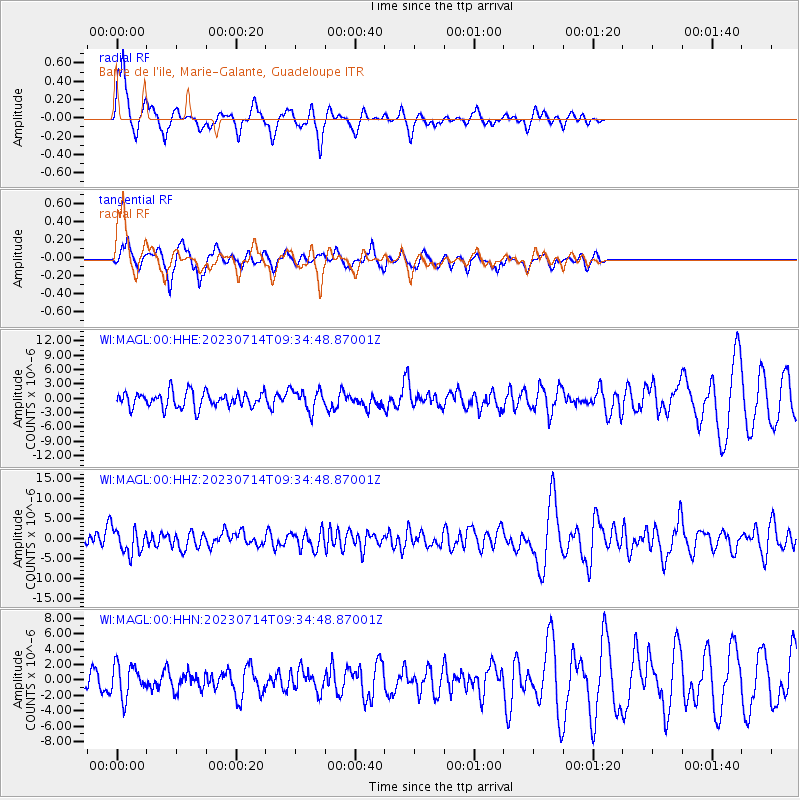
| Earthquake location: |
Near Coast Of Chiapas, Mexico |
| Earthquake latitude/longitude: |
15.0/-93.9 |
| Earthquake time(UTC): |
2023/07/14 (195) 09:29:01 GMT |
| Earthquake Depth: |
35 km |
| Earthquake Magnitude: |
6.3 mww |
| Earthquake Catalog/Contributor: |
NEIC PDE/us |
|
| Network: |
WI West Indies IPGP Network |
| Station: |
MAGL Barre de l'ile, Marie-Galante, Guadeloupe |
| Lat/Lon: |
15.95 N/61.28 W |
| Elevation: |
159 m |
|
| Distance: |
31.4 deg |
| Az: |
83.948 deg |
| Baz: |
272.823 deg |
| Ray Param: |
0.07903888 |
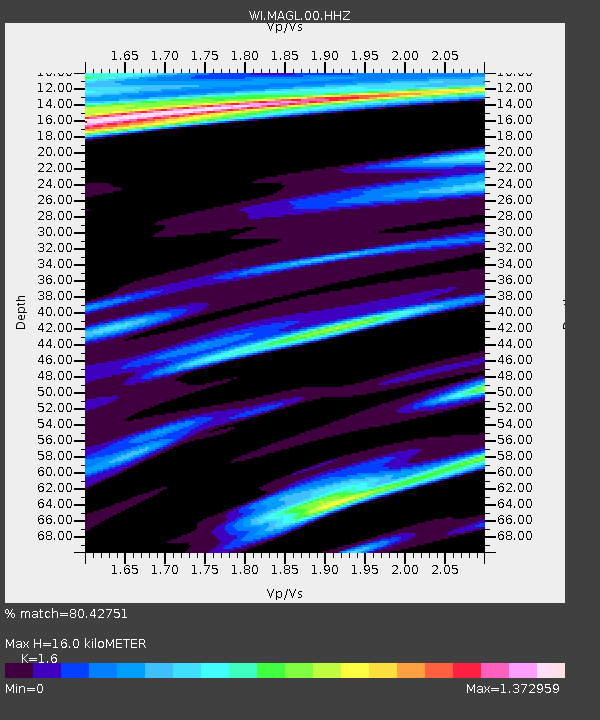
| Estimated Moho Depth: |
16.0 km |
| Estimated Crust Vp/Vs: |
1.60 |
| Assumed Crust Vp: |
5.88 km/s |
| Estimated Crust Vs: |
3.675 km/s |
| Estimated Crust Poisson's Ratio: |
0.18 |
|
| Radial Match: |
80.42751 % |
| Radial Bump: |
303 |
| Transverse Match: |
73.61617 % |
| Transverse Bump: |
396 |
| SOD ConfigId: |
30536071 |
| Insert Time: |
2023-07-28 10:05:03.840 +0000 |
| GWidth: |
2.5 |
| Max Bumps: |
400 |
| Tol: |
0.001 |
|
Signal To Noise
| Channel | StoN | STA | LTA |
| WI:MAGL:00:HHZ:20230714T09:34:48.87001Z | 2.014189 | 3.1123457E-6 | 1.5452102E-6 |
| WI:MAGL:00:HHN:20230714T09:34:48.87001Z | 1.7521969 | 2.0970267E-6 | 1.1967985E-6 |
| WI:MAGL:00:HHE:20230714T09:34:48.87001Z | 1.3531924 | 2.1814174E-6 | 1.6120526E-6 |
| Arrivals |
| Ps | 1.8 SECOND |
| PpPs | 6.6 SECOND |
| PsPs/PpSs | 8.3 SECOND |


