You are here: Home > Network List > AG - Arkansas Seismic Network Stations List
> Station WHAR Woolly Hollow State Park,AR > Earthquake Result Viewer
WHAR Woolly Hollow State Park,AR - Earthquake Result Viewer
| Earthquake location: |
Alaska Peninsula |
| Earthquake latitude/longitude: |
54.5/-160.8 |
| Earthquake time(UTC): |
2023/07/16 (197) 06:48:21 GMT |
| Earthquake Depth: |
21 km |
| Earthquake Magnitude: |
7.3 Mi |
| Earthquake Catalog/Contributor: |
NEIC PDE/at |
|
| Network: |
AG Arkansas Seismic Network |
| Station: |
WHAR Woolly Hollow State Park,AR |
| Lat/Lon: |
35.29 N/92.29 W |
| Elevation: |
184 m |
|
| Distance: |
50.1 deg |
| Az: |
83.099 deg |
| Baz: |
314.926 deg |
| Ray Param: |
0.06827895 |
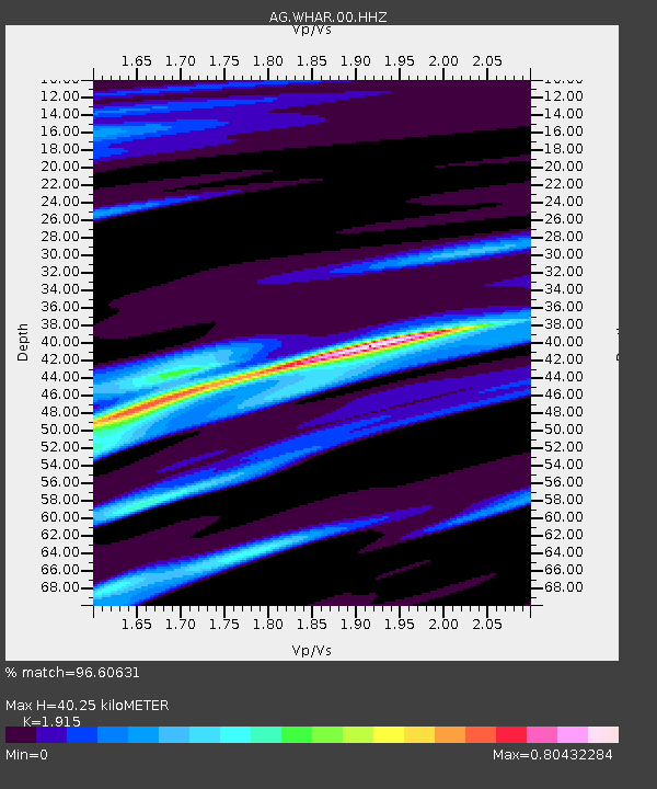
| Estimated Moho Depth: |
40.25 km |
| Estimated Crust Vp/Vs: |
1.91 |
| Assumed Crust Vp: |
6.498 km/s |
| Estimated Crust Vs: |
3.393 km/s |
| Estimated Crust Poisson's Ratio: |
0.31 |
|
| Radial Match: |
96.60631 % |
| Radial Bump: |
301 |
| Transverse Match: |
85.63324 % |
| Transverse Bump: |
400 |
| SOD ConfigId: |
30536071 |
| Insert Time: |
2023-07-30 06:52:38.266 +0000 |
| GWidth: |
2.5 |
| Max Bumps: |
400 |
| Tol: |
0.001 |
|

Signal To Noise
| Channel | StoN | STA | LTA |
| AG:WHAR:00:HHZ:20230716T06:56:43.269989Z | 32.08605 | 1.7709798E-6 | 5.51947E-8 |
| AG:WHAR:00:HHN:20230716T06:56:43.269989Z | 16.752321 | 8.369117E-7 | 4.9957954E-8 |
| AG:WHAR:00:HHE:20230716T06:56:43.269989Z | 16.632141 | 7.1715573E-7 | 4.3118664E-8 |
| Arrivals |
| Ps | 6.0 SECOND |
| PpPs | 17 SECOND |
| PsPs/PpSs | 23 SECOND |


