You are here: Home > Network List > AG - Arkansas Seismic Network Stations List
> Station XB03 El Dorado Temporary Station XB03 > Earthquake Result Viewer
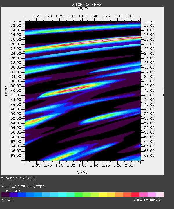
XB03 El Dorado Temporary Station XB03 - Earthquake Result Viewer
| Earthquake location: |
Alaska Peninsula |
| Earthquake latitude/longitude: |
54.5/-160.8 |
| Earthquake time(UTC): |
2023/07/16 (197) 06:48:21 GMT |
| Earthquake Depth: |
21 km |
| Earthquake Magnitude: |
7.3 Mi |
| Earthquake Catalog/Contributor: |
NEIC PDE/at |
|
| Network: |
AG Arkansas Seismic Network |
| Station: |
XB03 El Dorado Temporary Station XB03 |
| Lat/Lon: |
36.48 N/90.87 W |
| Elevation: |
144 m |
|
| Distance: |
50.0 deg |
| Az: |
80.939 deg |
| Baz: |
314.369 deg |
| Ray Param: |
0.06828808 |
| Estimated Moho Depth: |
18.25 km |
| Estimated Crust Vp/Vs: |
1.93 |
| Assumed Crust Vp: |
6.53 km/s |
| Estimated Crust Vs: |
3.375 km/s |
| Estimated Crust Poisson's Ratio: |
0.32 |
|
| Radial Match: |
92.64581 % |
| Radial Bump: |
400 |
| Transverse Match: |
74.66977 % |
| Transverse Bump: |
400 |
| SOD ConfigId: |
30536071 |
| Insert Time: |
2023-07-30 06:52:47.707 +0000 |
| GWidth: |
2.5 |
| Max Bumps: |
400 |
| Tol: |
0.001 |
|

Signal To Noise
| Channel | StoN | STA | LTA |
| AG:XB03:00:HHZ:20230716T06:56:43.170013Z | 3.4154842 | 1.1090608E-6 | 3.2471553E-7 |
| AG:XB03:00:HHN:20230716T06:56:43.170013Z | 1.5074581 | 4.5325237E-7 | 3.0067326E-7 |
| AG:XB03:00:HHE:20230716T06:56:43.170013Z | 2.31365 | 5.9632896E-7 | 2.577438E-7 |
| Arrivals |
| Ps | 2.8 SECOND |
| PpPs | 7.8 SECOND |
| PsPs/PpSs | 11 SECOND |


