You are here: Home > Network List > AZ - ANZA Regional Network Stations List
> Station RRSP RRSP, CA, USA > Earthquake Result Viewer
RRSP RRSP, CA, USA - Earthquake Result Viewer
| Earthquake location: |
Alaska Peninsula |
| Earthquake latitude/longitude: |
54.5/-160.8 |
| Earthquake time(UTC): |
2023/07/16 (197) 06:48:21 GMT |
| Earthquake Depth: |
21 km |
| Earthquake Magnitude: |
7.3 Mi |
| Earthquake Catalog/Contributor: |
NEIC PDE/at |
|
| Network: |
AZ ANZA Regional Network |
| Station: |
RRSP RRSP, CA, USA |
| Lat/Lon: |
33.65 N/116.74 W |
| Elevation: |
1610 m |
|
| Distance: |
37.1 deg |
| Az: |
105.884 deg |
| Baz: |
317.721 deg |
| Ray Param: |
0.07631861 |
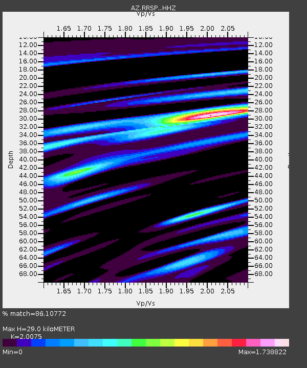
| Estimated Moho Depth: |
29.0 km |
| Estimated Crust Vp/Vs: |
2.01 |
| Assumed Crust Vp: |
6.264 km/s |
| Estimated Crust Vs: |
3.12 km/s |
| Estimated Crust Poisson's Ratio: |
0.33 |
|
| Radial Match: |
86.10772 % |
| Radial Bump: |
400 |
| Transverse Match: |
66.54708 % |
| Transverse Bump: |
400 |
| SOD ConfigId: |
30536071 |
| Insert Time: |
2023-07-30 06:53:56.855 +0000 |
| GWidth: |
2.5 |
| Max Bumps: |
400 |
| Tol: |
0.001 |
|

Signal To Noise
| Channel | StoN | STA | LTA |
| AZ:RRSP: :HHZ:20230716T06:54:59.014008Z | 7.8853955 | 1.037842E-6 | 1.3161574E-7 |
| AZ:RRSP: :HHN:20230716T06:54:59.014008Z | 4.973771 | 5.443204E-7 | 1.09438176E-7 |
| AZ:RRSP: :HHE:20230716T06:54:59.014008Z | 2.7014916 | 3.9562912E-7 | 1.464484E-7 |
| Arrivals |
| Ps | 5.0 SECOND |
| PpPs | 13 SECOND |
| PsPs/PpSs | 18 SECOND |


