You are here: Home > Network List > CA - Catalan Seismic Network Stations List
> Station CLLI Llivia > Earthquake Result Viewer
CLLI Llivia - Earthquake Result Viewer
| Earthquake location: |
Alaska Peninsula |
| Earthquake latitude/longitude: |
54.5/-160.8 |
| Earthquake time(UTC): |
2023/07/16 (197) 06:48:21 GMT |
| Earthquake Depth: |
21 km |
| Earthquake Magnitude: |
7.3 Mi |
| Earthquake Catalog/Contributor: |
NEIC PDE/at |
|
| Network: |
CA Catalan Seismic Network |
| Station: |
CLLI Llivia |
| Lat/Lon: |
42.48 N/1.97 E |
| Elevation: |
1413 m |
|
| Distance: |
82.3 deg |
| Az: |
12.776 deg |
| Baz: |
349.956 deg |
| Ray Param: |
0.04697546 |
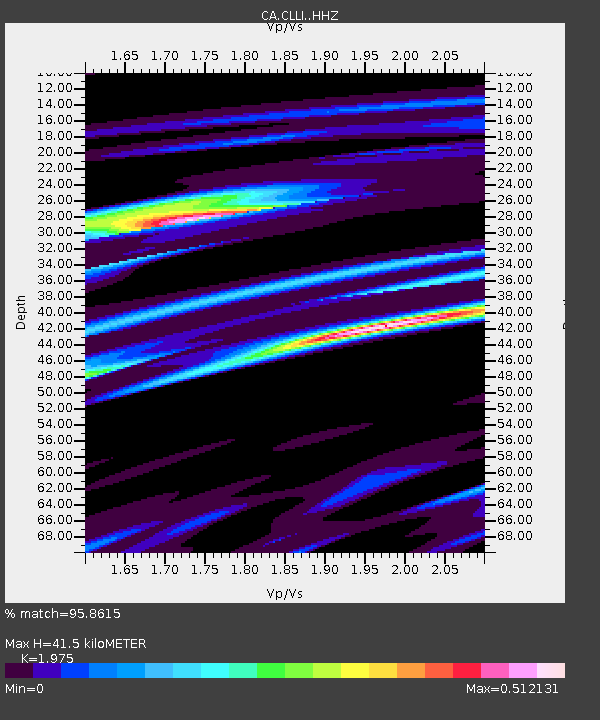
| Estimated Moho Depth: |
41.5 km |
| Estimated Crust Vp/Vs: |
1.98 |
| Assumed Crust Vp: |
6.416 km/s |
| Estimated Crust Vs: |
3.249 km/s |
| Estimated Crust Poisson's Ratio: |
0.33 |
|
| Radial Match: |
95.8615 % |
| Radial Bump: |
280 |
| Transverse Match: |
90.98698 % |
| Transverse Bump: |
400 |
| SOD ConfigId: |
30536071 |
| Insert Time: |
2023-07-30 06:55:51.986 +0000 |
| GWidth: |
2.5 |
| Max Bumps: |
400 |
| Tol: |
0.001 |
|

Signal To Noise
| Channel | StoN | STA | LTA |
| CA:CLLI: :HHZ:20230716T07:00:09.469971Z | 31.742338 | 6.2460044E-6 | 1.9677204E-7 |
| CA:CLLI: :HHN:20230716T07:00:09.469971Z | 12.419732 | 1.9262038E-6 | 1.5509221E-7 |
| CA:CLLI: :HHE:20230716T07:00:09.469971Z | 6.5719705 | 1.0309608E-6 | 1.568724E-7 |
| Arrivals |
| Ps | 6.5 SECOND |
| PpPs | 19 SECOND |
| PsPs/PpSs | 25 SECOND |


