You are here: Home > Network List > CA - Catalan Seismic Network Stations List
> Station CSOR Soriguera > Earthquake Result Viewer
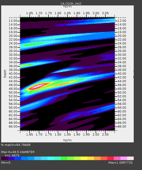
CSOR Soriguera - Earthquake Result Viewer
| Earthquake location: |
Alaska Peninsula |
| Earthquake latitude/longitude: |
54.5/-160.8 |
| Earthquake time(UTC): |
2023/07/16 (197) 06:48:21 GMT |
| Earthquake Depth: |
21 km |
| Earthquake Magnitude: |
7.3 Mi |
| Earthquake Catalog/Contributor: |
NEIC PDE/at |
|
| Network: |
CA Catalan Seismic Network |
| Station: |
CSOR Soriguera |
| Lat/Lon: |
42.37 N/1.13 E |
| Elevation: |
1227 m |
|
| Distance: |
82.3 deg |
| Az: |
13.413 deg |
| Baz: |
349.477 deg |
| Ray Param: |
0.046981968 |
| Estimated Moho Depth: |
46.5 km |
| Estimated Crust Vp/Vs: |
1.69 |
| Assumed Crust Vp: |
6.416 km/s |
| Estimated Crust Vs: |
3.802 km/s |
| Estimated Crust Poisson's Ratio: |
0.23 |
|
| Radial Match: |
94.79689 % |
| Radial Bump: |
400 |
| Transverse Match: |
84.62963 % |
| Transverse Bump: |
400 |
| SOD ConfigId: |
30536071 |
| Insert Time: |
2023-07-30 06:55:58.813 +0000 |
| GWidth: |
2.5 |
| Max Bumps: |
400 |
| Tol: |
0.001 |
|

Signal To Noise
| Channel | StoN | STA | LTA |
| CA:CSOR: :HHZ:20230716T07:00:09.419983Z | 26.832563 | 6.214608E-6 | 2.3160695E-7 |
| CA:CSOR: :HHN:20230716T07:00:09.419983Z | 8.745787 | 1.5109515E-6 | 1.7276336E-7 |
| CA:CSOR: :HHE:20230716T07:00:09.419983Z | 3.3584678 | 5.390639E-7 | 1.6050888E-7 |
| Arrivals |
| Ps | 5.1 SECOND |
| PpPs | 19 SECOND |
| PsPs/PpSs | 24 SECOND |


