You are here: Home > Network List > CI - Caltech Regional Seismic Network Stations List
> Station FMP Fort MacArthur Park, Pt. Fermin San Pedro, CA, USA > Earthquake Result Viewer
FMP Fort MacArthur Park, Pt. Fermin San Pedro, CA, USA - Earthquake Result Viewer
| Earthquake location: |
Alaska Peninsula |
| Earthquake latitude/longitude: |
54.5/-160.8 |
| Earthquake time(UTC): |
2023/07/16 (197) 06:48:21 GMT |
| Earthquake Depth: |
21 km |
| Earthquake Magnitude: |
7.3 Mi |
| Earthquake Catalog/Contributor: |
NEIC PDE/at |
|
| Network: |
CI Caltech Regional Seismic Network |
| Station: |
FMP Fort MacArthur Park, Pt. Fermin San Pedro, CA, USA |
| Lat/Lon: |
33.71 N/118.29 W |
| Elevation: |
89 m |
|
| Distance: |
36.2 deg |
| Az: |
107.428 deg |
| Baz: |
318.102 deg |
| Ray Param: |
0.076825336 |
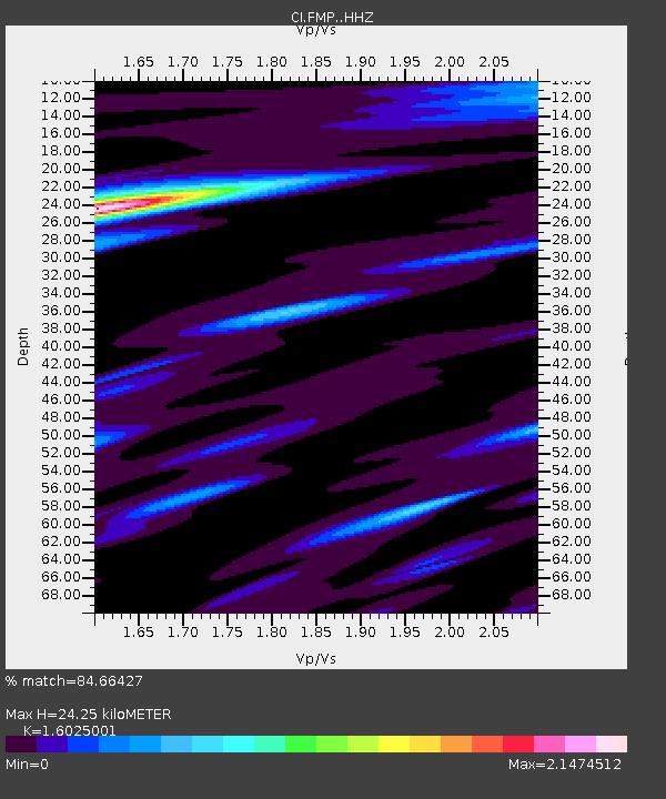
| Estimated Moho Depth: |
24.25 km |
| Estimated Crust Vp/Vs: |
1.60 |
| Assumed Crust Vp: |
6.048 km/s |
| Estimated Crust Vs: |
3.774 km/s |
| Estimated Crust Poisson's Ratio: |
0.18 |
|
| Radial Match: |
84.66427 % |
| Radial Bump: |
400 |
| Transverse Match: |
59.8577 % |
| Transverse Bump: |
400 |
| SOD ConfigId: |
30536071 |
| Insert Time: |
2023-07-30 06:57:23.553 +0000 |
| GWidth: |
2.5 |
| Max Bumps: |
400 |
| Tol: |
0.001 |
|
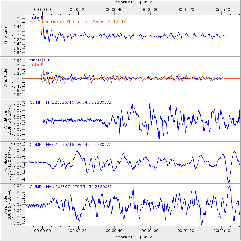
Signal To Noise
| Channel | StoN | STA | LTA |
| CI:FMP: :HHZ:20230716T06:54:51.238007Z | 6.307613 | 1.4069645E-6 | 2.2305815E-7 |
| CI:FMP: :HHN:20230716T06:54:51.238007Z | 2.130054 | 8.12578E-7 | 3.8148232E-7 |
| CI:FMP: :HHE:20230716T06:54:51.238007Z | 1.7732369 | 7.073966E-7 | 3.989296E-7 |
| Arrivals |
| Ps | 2.6 SECOND |
| PpPs | 9.7 SECOND |
| PsPs/PpSs | 12 SECOND |


